
The Polish Geological Survey - WL is the general contractor of serial hydrogeological maps. We coordinate, supervise and create thematic maps in detailed and overview scales as well as regional hydrogeological syntheses in the form of atlases and monographs.
Hydrogeological Map of Poland
The Polish Geological Institute is the GENERAL CONTRACTOR OF THE 1:50,000 HYDROGEOLOGICAL MAP OF POLAND (MhP). The Map was requested by the Ministry of the Environment and financed from resources of the National Fund for Environmental Protection and Water Management.
THE FIRST EDITION OF THE HYDROGEOLOGICAL MAP OF POLAND was made between 1996 and 2004. The 1069 sheets, covering the area of the whole Poland, were developed in four two-year stages.
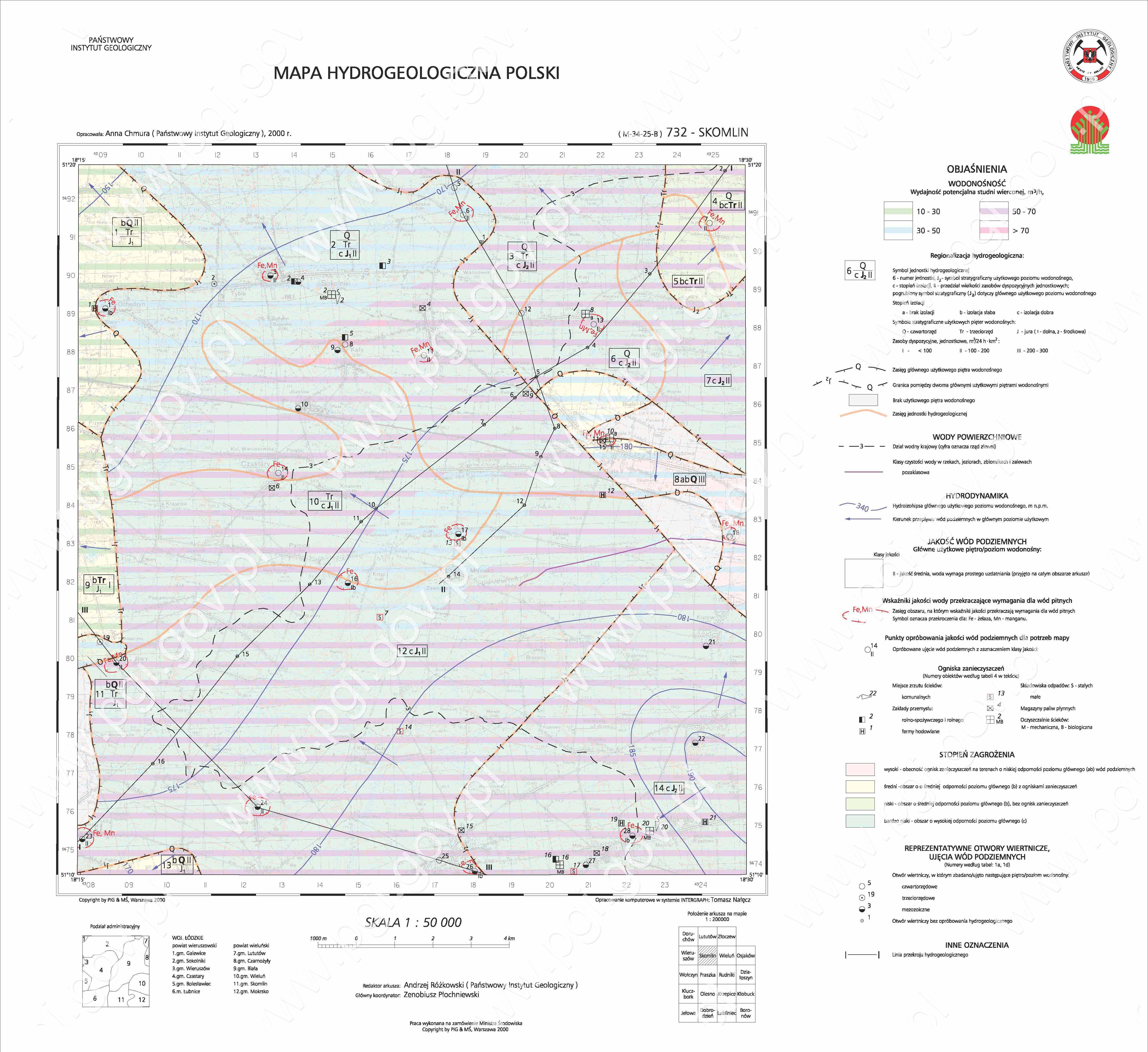
Fig. 1. Example of the 1:50,000 Hydrogeological Map of Poland
The Hydrogeological Map of Poland is a serial map, consisting of a number of sheets, made on a 1:50,000 topographic base map under the 1942 coordinate system. The map is uniform as regards the scope and presentation of information layers. Each map sheet is a separate GIS hydrogeological database using the Intergraph software system (digital representation in MGE/Microstation programs, in the form of digital exports and databases (Oracle)).
The Hydrogeological Map of Poland contains information on useful aquifers of standard groundwaters with a broader interpretation of the main aquifer, which is the most important water supply source.
Information layers of the Hydrogeological Map of Poland – identification of the main useful aquifer and its characteristics as regards:
- range and depth, as well as thickness and conductivity,
- quality of groundwaters as a source of consumption water for people,
- degree to which groundwaters are exposed to the risk of surface contaminants,
- discharge possibilities of a typical drilled well,
- current level of groundwater tables and the direction of their flow,
- renewability of groundwater resources and their acceptable management.
The Hydrogeological Map of Poland provides the location of groundwater intakes and their technical and hydrogeological characteristics, as well as the location and simplified characteristics of facilities that are harmful to groundwaters.ONCE THE 1ST EDITION OF THE HYDROGEOLOGICAL MAP OF POLAND (THE SHEET VERSION) WAS COMPLETED, the following activities were undertaken:
- the data was combined into one map by transferring the GIS sheet databases to the spatially continuous Hydrogeological Map of Poland using the INTERGRAPH GeoMedia Professional environment, which permits effective work with the Map within freely defined borders (topographic base map, voivodeship, poviat, catchment, water region, landscape park etc.) of varied sets of information (selected elements, combinations with other maps)
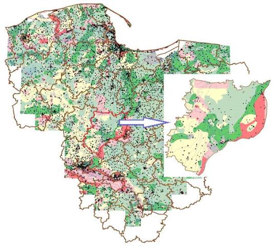
Fig. 2. Example of the spatially continuous GIS Hydrogeological Map of Poland
- exchange of information layers of the Hydrogeological Map of Poland connected with the standards introduced (e.g. with the Map of the Hydrographic Division of Poland, classification for presenting water conditions);
- systematic update of the Hydrogeological Map of Poland database (e.g. update of layers the parameters of which change in time, supplementation and verification of object-oriented databases),
- adding new information layers to the Hydrogeological Map of Poland database (hydrogeological characteristics of the first aquifer)
- developing the software for obtaining and mapping information layers
AREAS OF APPLICATION OF THE 1:50,000 HYDROGEOLOGICAL MAP OF POLAND:
- delineation, characteristics of parameters and assessment of groundwater bodies,
- keeping the list of groundwaters that are the source of water supply for people,
- designing groundwater intakes and protection zones,
- preparing groundwater protection programmes, environmental protection,
- documenting major groundwater reservoirs and their protection areas,
- designing and conducting regional and local hydrogeological studies,
- preparing opinions on permits required under the Water Law Act for water use,
- developing water management plans and water use conditions,
- planning water management investments,
- spatial planning (land development directions),
- issuing decisions connected with the location of enterprises harmful to the environment.
ACCESS TO THE HYDROGEOLOGICAL MAP OF POLAND is provided by the Polish Geological Institute (Central Geological Archive) at the user’s request. The Hydrogeological Map of Poland is available in the following versions:
- plotter version – printout of the main chart, documentation map, explanatory text with database tables, thematic maps, cross-sections and charts
- electronic (a digital project)
Access to the Hydrogeological Map of Poland – National Geological Archive, Polish Geological Institute National Reasearch Institue in Warsaw, ul. Rakowiecka 4. >>
NOTE: the Hydrogeological Map of Poland database contains both open and confidential content.