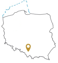
Acreage: 83.25 km2
Concession blocks: 410, 411
Coordinates [1992]
| No. Point | x [PUWG92] | y [PUWG92] |
| 1 | 229422,37 | 493418,39 |
| 2 | 229341,87 | 499174,04 |
| 3 | 229313,02 | 499187,43 |
| 4 | 229289,57 | 500124,17 |
| 5 | 226858,38 | 500124,08 |
| 6 | 226943,36 | 507622,42 |
| 7 | 222293,28 | 507622,86 |
| 8 | 222190,12 | 494662,22 |
| 9 | 222153,81 | 493303,33 |
Location
Śląskie province:
- Bielsko-Biała county, communes: Bestwina (participation in the tender area: 20.97%), urban- rural Czechowice-Dziedzice (61.41%), Jasienica (2.47%), urban- rural
- Bielsko-Biała city county, commune: urban Bielsko-Biała (6.12%)
- Pszczyna county, commune: Goczałkowice-Zdrój (6.92%)
Duration
concession for 30 years, including:
- prospecting and exploration phase (5 years)
- extracting phase (25 years)
Structural stages
- Alpine (Carpathians and Carpathian Foredeep)
- Variscan (Devonian and Carboniferous basement of Carpathian units; Lower Paleozoic of the Upper Silesian block)
- Precambrian
Petroleum Systems
I – autochthonous Miocene of the Carpathian Foredeep
II – Paleozoic basement of the Carpathians
Source rocks
I – claystones and mudstones of the Skawina Formation of the Carpathian Foredeep
II – fine-clastc rocks of the Upper Carboniferous (paralic and limnic series) of the Carpathian basement
Reservoir rocks
I – conglomerates, sandstones, sands and mudstones of the Dębowiec and Skawina formations of the Carpathian Foredeep
II – Lower Devonian sandstones, Middle and Upper Devonian and Lower Carboniferous limestones and dolomites, sandstones and mudstones of paralic and limnic series of the Upper Carboniferous and coal beds of the Carpathian basement
Seal rocks
I – numerous layers of claystones within the autochtonous Miocene of the Carpathian Foredeep, flysch deposits of the Subsilesian or Silesian units
II – fine-grained clastic rocks of the autochtonous Miocene of the Carpathian Foredeep, claystones and mudstones of the Subsilesia and Silesia flysch successions, fine-grained clastic rocks of the Upper Carboniferous paralic and limnic series
Proposed minimum work program of prospecting and exploration phase
Stage I (12 months) – reprocessing and reinterpretation of archival geological data
Stage II (48 months) – conduct of geophysical investigations – 30 km 2D seismic survey or 15 km2 3D seismic survey; drilling of one well to the maximal depth of 2500 m TVD with obligatory coring of prospective intervals
