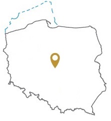
Acreage: 702.48 km2
Concession blocks: 270, 290
Coordinates [1992]
| No. Point | x [PUWG92] | y [PUWG92] |
| 1 | 422699,68 | 465433,21 |
| 2 | 422598,89 | 480146,84 |
| 3 | 415125,67 | 477759,62 |
| 4 | 402260,28 | 486821,61 |
| 5 | 394857,71 | 500000,00 |
| 6 | 387287,14 | 500000,00 |
| 7 | 387359,94 | 478635,54 |
| 8 | 400377,34 | 465280,57 |
| Excluding the zone (planned for further exploitation of brown coal deposit) designated by points A-D and the level of 170 m b.s.l. | ||
| A | 387345,52 | 482868,43 |
| B | 393675,46 | 482954,71 |
| C | 393824,86 | 472002,97 |
| D | 387359,94 | 478635,54 |
Location
Łódzkie province:
- Bełchatów county, commune: Rusiec (participation in the tender area: 0.55%)
- Łask county, commune: Widawa (14.53%)
- Sieradz county, communes: urban-rural Błaszki (2.63%), Brąszewice (2.88%), Brzeźnio (18.29%), Burzenin (14.71%), urban Sieradz (1.29%), Sieradz (9.63%), urban-rural Warta (2.20%), Wróblew (16.05%), urban-rural Złoczew (10.39%)
- Wieluń county, communes: Konopnica (6.75%), Ostrówek (0.10%)
Duration
Concession for 30 years, including:
- prospecting and exploration phase (5 years)
- extracting phase (25 years)
Source rocks
I – organic - rich interbeds within the Zechstein / Main Dolomite
II – Lower Carboniferous clastones and mudstones
Reservoir rocks
I – Zechstein / Main Dolomite carbonates
II – Carboniferous and Rotliegend sandstones, Zechstein Limestone carbonates
Proposed minimum work program of prospecting and exploration phase
Stage I (12 months) – interpretation and analysis of archival geological data
Stage II (48 months) – conduct of geophysical investigations – 200 km 2D seismic survey or 100 km2 3D seismic survey; drilling of one well to the maximal depth of 3500 m TVD with obligatory coring of prospective intervals
