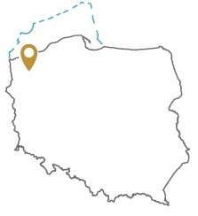
Acreage: 990.32 km2
Concession blocks: 82, 83, 103
Coordinates [1992]
| No. Point | x [PUWG92] | y [PUWG92] |
| 1 | 673948,18 | 266614,09 |
| 2 | 669360,76 | 269798,54 |
| 3 | 643263,52 | 268511,84 |
| 4 | 645106,88 | 235462,62 |
| 5 | 661436,72 | 236382,04 |
| 6 | 661143,42 | 240603,82 |
| 7 | 664525,57 | 238976,42 |
| 8 | 664755,54 | 236443,29 |
| 9 | 675598,09 | 237055,20 |
Location
Zachodniopomorskie province:
- Goleniów country, communes: urban-rural Maszewo (participation in the tender area: 0.11%), urban-rural Nowogard (28.47%), Osina (2.45%)
- Gryfice county, communes: urban-rural Gryfice (8.06%), urban-rural Płoty (19.19%)
- Kamieńsk county, commune: urban-rural Golczewo (4.41%)
- Łobez county, communes: urban-rural Dobra (1.52%), urban-rural Łobez (0.06%), Radowo Małe (15.49%), urban-rural Resko (19.41%), urban-rural Węgorzyno (0.84%)
Duration
Concession for 30 years, including:
- prospecting and exploration phase (5 years)
- extracting phase (25 years)
Source rocks
I – organic - rich interbeds within the Zechstein / Main Dolomite
II –Carboniferous clastones and mudstones
Reservoir rocks
I – Zechstein / Main Dolomite carbonates
II – Carboniferous and Rotliegend sandstones
Proposed minimum work program of prospecting and exploration phase
Stage I (12 months) – reprocessing, integration and reinterpretation of archival seismic and borehole data
Stage II (48 months) – conduct of geophysical investigations – 90 km 2D seismic survey or 45 km2 3D seismic survey; drilling of one well to the maximal depth of 6000 m TVD with obligatory coring of prospective intervals
