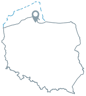
Acreage: 900.35 km2
Concession blocks: 49
Coordinates [1992]
| No. point | x [PUWG92] | y [PUWG92] |
| 1 | 709648,50 | 467438,93 |
| 2 | 709994,91 | 434842,34 |
| 3 | 737770,93 | 435133,01 |
| 4 | 737259,22 | 467502,29 |
| 5 | 720361,13 | 467514,79 |
Location
Pomorskie province:
- Gdańsk city county, commune Gdańsk city (participation in the tender area: 4.26%)
- Gdańsk county, communes: Kolbudy (3.63%), Przywidz (1.33%)
- Gdynia city county, communes Gdynia city (3.89%)
- Kartuzy county, communes: Chmielno (8.13%), Kartuzy (20.22%), Przodkowo (9.45%), Sierakowice (0.12%), Somonino (6.90%), Stężyca (0.84%), Żukowo (18.19%)
- Wejherowo county, communes: Linia (5.44%), Luzino (0.88%), Łęczyce (<0.01%), Szemud (16.61%), Wejherowo (0.12%)
Duration
concession for 30 years, including:
- prospecting and exploration phase (5 years)
- extracting phase (25 years)
Structural stages
- Cenozoic
- Laramian (Permian and Mesozoic)
- Caledonian (Ediacaran and Lower Paleozoic)|
- Precambrian
Petroleum Systems
I. Middle Cambrian (conventional and unconventional tight gas)
II. Lower Palaeozoic shale gas and shale oil (unconventional)
III. Zechstein/Main Dolomite (conventional)
Source rocks
I, II. Upper Cambrian, Ordovician and Silurian fine-grained clastic rocks
III. Unidentified
Reservoir rocks
I. Middle Cambrian sandstones
II. Ordovician and Silurian claystones and mudstones
III. Main Dolomite carbonate rocks
Seal rocks
I, II. Ordovician and SIlurian fine-grained clastic rocks; Zechstein evaporites
III. Zechstein evaporites
Trap type
I. Structural, lithological, stratigraphic, mixed, continuous
II. Continuous
III. Structural, stratigraphic
