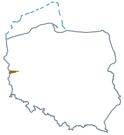
Acreage: 668,50 km2
Concession blocks: 222, 223
Coordinates [1992]
| No. Point | x [PUWG92] | y [PUWG92] |
| 1 | 492887.97 | 260981.45 |
| 2 | 492844.21 | 261045.53 |
| 3 | 487287.05 | 260776.88 |
| 4 | 489935.10 | 244937.94 |
| 5 | 484261.45 | 246929.48 |
| 6 | 481351.42 | 231859.04 |
| 7 | 477639.79 | 215436.67 |
| 8 | 475861.85 | 213502.89 |
| 9 | 475467.68 | 212006.81 |
| 10 | 475232.69 | 209573.34 |
| 11 | 475217.79 | 209419.08 |
| between points 11 and 12 along the state border | ||
| 12 | 495843.73 | 206676.28 |
Location
- onshore
Lubuskie province:
- Krosno Odrzańskie county, communes: Bytnica (19.30%of the area), Gubin (0.32%), Krosno Odrzańskie (0.23%), Maszewo (22.09%),
- Słubice county, cummune: Cybinka (31.52%),
- Sulęcin county, commune: Torzym (8.45%),
- Świebodzin county, communes: Lubrza (2.85%), Łagów (9.75%), Skąpe (1.83%), Świebodzin (3.66%).
