Polish Geological Institute – National Research Institute
Engineering Geology and Shallow Geothermal Energy Department
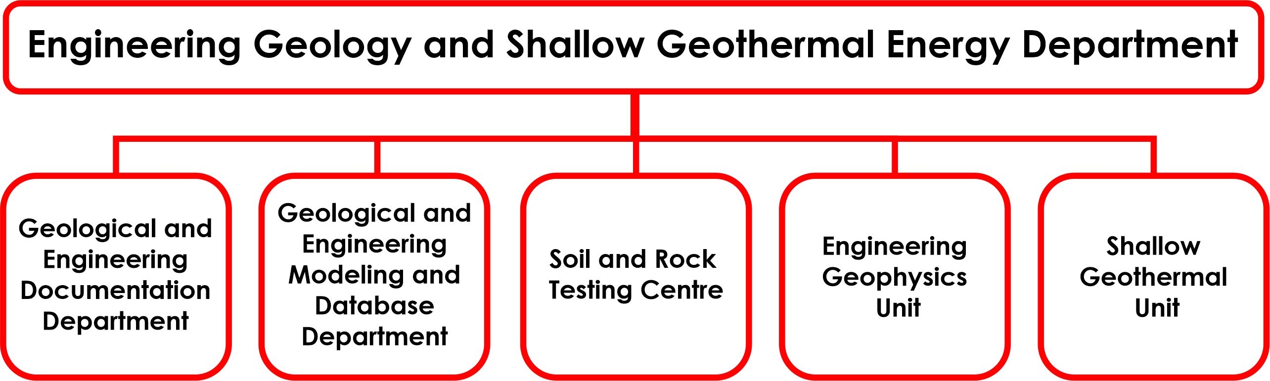
The scope of activities of the Engineering Geology and Shallow Geothermal Energy Department includes work in the fields of engineering geology and geotechnics, shallow geothermal energy, including low-temperature geothermal energy and engineered geothermal energy, engineering geophysics, subsoil investigation, as well as laboratory testing of soils and rocks. In 2024, the Department was divided into five internal units:
Our activities include:
- spatial planning;
- underground space management;
- urban geology;
- identification of optimal locations;
- assessment of the suitability of areas for investments involving building structures and underground structures;
- foundation of building structures;
- assessment of the thermal potential of soils and rocks for shallow geothermal energy.
The detailed scope of activities of the Department includes:
- substantive management of engineering geological, shallow geothermal and engineering geophysics databases;
- acquisition and collection of new geological data in databases and management of, in particular, the Geo-engineering Database (BDGI), the Database of Physical and Mechanical Properties of Soils and Rocks (BDGI-WFM), the Polish Geo-Engineeringl Map Database (BDMgiP), the National GIS database on low-temperature geothermal energy (BDGN) and the Engineering Geophysics Database;
- development of engineering geological cartographic products and 3D/4D geological modelling for marine and onshore areas using modern tools, in particular the preparation of Engineering Geological Atlases, engineering geological maps of Poland, including the series of the Engineering Geological Map of Poland at a scale of 1:50,000 (MgiP50k), as well as geothermal potential maps, including the series of the Shallow Geothermal Energy Potential Map of Poland at a scale of 1:50,000 (MPGN);
- conducting work on the standardisation of data concerning the management of information on the subsoil of building structures (geoBIM) and cities (geoCIM, SmartCity), as well as the integration of these standards with European standards and OGC standards; design and performance of geophysical surveys and engineering geological investigations, including geotechnical soundings, geothermal investigations of soils and rocks, and sampling of soils and rocks for laboratory testing;
- conducting laboratory testing of the physical, mechanical, filtration and thermal properties of soil and rock samples, as well as determining soil and rock parameters;
- supporting environmental monitoring using geophysical methods;
- preparation of designs, documentation, expert reports, opinions, analyses, assessments, forecasts and reports, including reports on laboratory testing and sampling;
- conducting studies, analyses and research into the possibilities of developing new forms of underground space management, the location of strategic facilities and facilities related to the energy transition, in particular nuclear facilities, surface and underground waste disposal facilities, including radioactive waste and carbon dioxide, as well as underground storage facilities for substances and thermal energy in closed-loop systems such as BTES and engineered systems such as PTES/TTES and EF/TG;
- providing technical consultancy for investment projects, including, in particular, reviewing documents for compliance with legal regulations, providing consultancy services, and conducting supervision, inspection and control of geological works in the country and in marine areas;
- dissemination and promotion of knowledge in the field of engineering geology and investigations of the soil-rock medium, as well as promotion of the results of the work carried out through the preparation of methodological guides, guidelines and instructions, establishing standards for work, organising conferences and training courses, and actively participating in industry events in Poland and abroad;
- conducting scientific research, methodological and experimental work, as well as the implementation and commercialisation of their results;
- improvement and implementation of new research methods and techniques (field investigations, laboratory testing and engineering geophysics surveys), in particular at experimental sites, depending on regional geological conditions, as well as the development of modern methods for data collection and processing, including modelling techniques and automation of engineering geological data analysis processes;
- conducting national and international cooperation, in particular with European geological surveys;
- supporting central and local government authorities, state institutions, in particular those responsible for national defence, as well as the public and businesses in matters related to engineering geology.