


 The European WATERPROTECT project - Innovative tools enabling drinking WATER PROTECTion in rural and urban environments is coming to an end. It lasted over 3 years and was financed from EU funds under the Horizon 2020 program. Its main goal was to develop modern principles of water resource management and effective water protection in areas intensively used for agriculture.
The project was carried out in 7 countries in various pilot areas. In Poland, it was the catchment area of the Gowienica Miedwiańska River in the West Pomeranian Voivodeship. The project, together with the Polish Geological Institute - NRI, was attended by the West Pomeranian University of Technology in Szczecin and the Institute of Technology and Life Sciences, and also: the Provincial Inspectorate for Environmental Protection in Szczecin, the Regional Water Management Authority in Szczecin, the West Pomeranian Agricultural Advisory Center, West Pomeranian Waterworks, Water and Sewerage Office in Szczecin and the Head of the Warnice Commune.
One of the conditions for sustainable water management is easy access to specific information from a given area. Therefore, as part of the project, it was planned to build a tool allowing for simple and quick access to integrated data. In Poland, the knowledge and experience of the CBDG team and IT solutions already functioning at PGI-NRI were used for the project.
As a result, the work was created repository database collects historical data and collected during the project. Data from 6 different sources were harmonized:
- Polish Geological Institute - NRI
- Water and Sewerage Office in Szczecin
- West Pomeranian University of Technology
- Institute of Technology and Life Sciences
- Provincial Inspectorate for Environmental Protection
- The State Water Holding Polish Waters
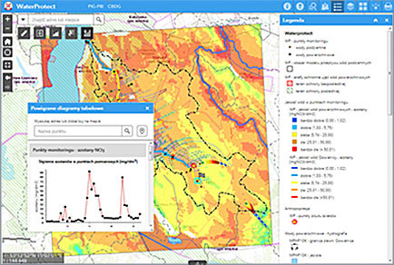
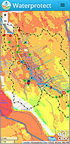
As a result of the work, a repository containing unified data was created. It has become a data source for mapping services for publication on the internet. For their presentation, solutions that have been proven for many years to present CBDG data were used: the Portal GEOLOGIA and the mobile application GeoLOG. For the Waterprotect project, dedicated versions of these applications were created. They offer previously known functionalities, and in addition, the WATERPROTECT Portal has been enriched with tools for viewing measurement data in the form of graphs, including from several points simultaneously.
Portal WATERPROTECT Mobile application WATERPROTECT
https://geologia.pgi.gov.pl/waterprotect/
https://waterprotect.pgi.gov.pl/
A short film was also prepared as part of the project. It presents the most important information about the built IT solution.
Waterprotect promotional video (YouTube)
Text: Wojciech Paciura
 PGI-NRI offer
 Mineral resources of Poland
  Oil and Gas in Poland


 Subscribe to RSS Feed