


 PGI is the administrator for the Geo-engineering Database (BDGI) - the largest Polish digital database of data useful in construction, spatial planning and crisis management. High quality of data, quick and free access and an intuitive interface, make it a valuable and main source of knowledge for a wide group of interested parties.
The Geo-engineering Database collects data from over 400,000 boreholes. The data include the type of soils and rocks, their age and genesis and documented occurrence of groundwater. The database also includes results of studies on physical and mechanical properties of soils and rocks for selected boreholes.
The data gathered in the BDGI enables a preliminary reconnaissance of geological structure, the construction and hydrogeological conditions and the bearing capacity of subsoil in the place of the planned investment. They are also helpful in selecting the optimum location for large cubature investments (e.g. housing estates) or in the process of delineating routes of linear investments and underground infrastructure (e.g. subways, road and railroad lines, tunnels, gas pipelines). The BDGI is dedicated for geological and construction companies, investors, universities, research institutes and geological and local government administration.
The Geo-engineering Database is a source of information which enables the modelling and visualization of geological conditions under the largest Polish cities
BDGI, available via the link geologia.pgi.gov.pl (tab: Budownictwo), currently gathers all information in one location. Initially it consisted of 9 different and incompatible databases. Their merging was an important and large undertaking which resulted in one common database scheme with unified dictionaries of lithology, stratigraphy, genesis and geo-engineering soil classification, and covered the entirety of geological data gathered in the database (over 400,000 boreholes and over 3200 sheets of engineering-geological maps in the scale 1:10,000 and 1:100,000). For creating the BDGI, the Institute was awarded the international SAG (Special Achievement in GIS Award) at the ESRI User Conference 2019 in San Diego (USA). This award is given for outstanding achievements in working with GIS technology.
So far, 15 geo-engineering atlases have been completed as part of the BDGI project, two more (for Szczecin and Lublin-Świdnik) are being prepared and will be completed in 2021, and feasibility studies are being elaborated for another 18 locations (the full list is available at geoportal.pgi.gov.pl/atlasy_gi/project/realization). The atlases mainly concern cities with the most intensive urban development. They also cover selected stretches of the Baltic coastal zone (e.g. areas of the Gdynia and Kaszuby cliffs), where intensive geodynamic processes are taking place. The contents of the atlases, together with other data derived from geo-engineering, hydrogeological and resource deposit documentation, make up a detailed database for the whole country.
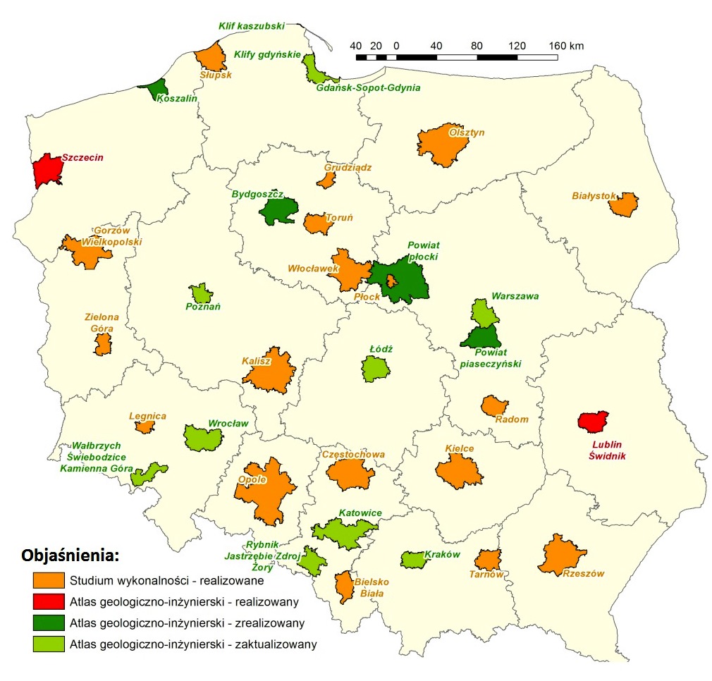
Geo-engineering atlases - status of work
The BDGI project involved the preparation of over 3200 sheets of geo-engineering maps in the 1:10,000 scale. They may be downloaded from the servers of the Central Geological Database - CBDG (geologia.pgi.gov.pl, tab: Budownictwo) in just a few clicks.
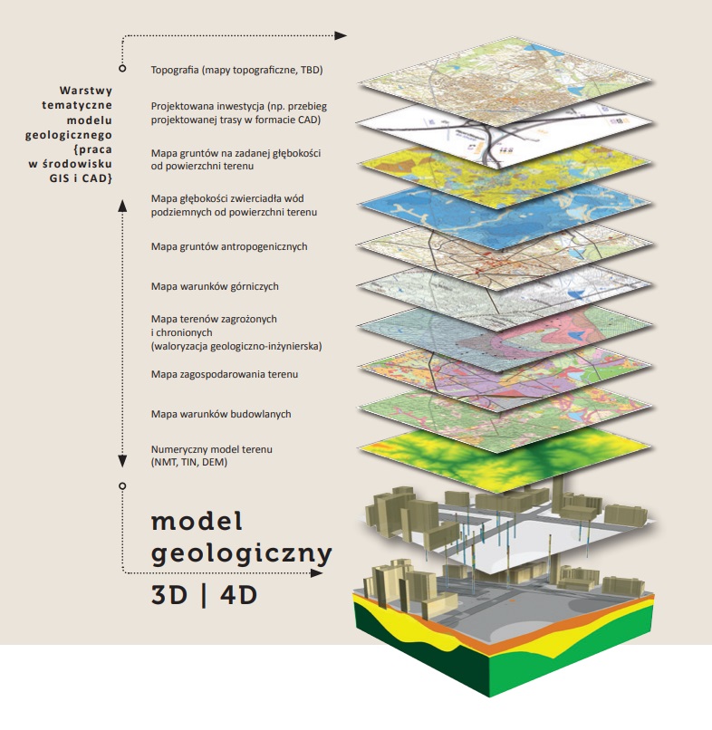
The primary tools used in running the BDGI are software packages that act as an interface for inputting and managing drill data and are used to generate and symbolize spatial layers and publish them as map sheets. The spatial information layers collected in the BDGI encompass a wide range of data. The main layers are:
- Documentation map, scale: 1:10,000,
- Maps of geo-engineering soil classification at depths of 1, 2, 4, and 5 m below ground level, scale: 1:10 000,
- Map of anthropogenic soils, scale: 1:10,000,
- Map of construction conditions at the depth of 2 m below ground level, scale: 1:10,000,
- Map of the depth to the first groundwater table, scale: 1:10,000,
- Map of land management, scale: 1:10,000,
- Map of endangered and protected areas, scale: 1:10,000,
- Map of mining conditions, scale: 1:10,000,
- Geohazard map, scale: 1:10,000,
- Location map, scale: 1:100,000,
- Geomorphological map, scale: 1:100,000,
- Map of the extent of documentation, scale: 1:100 000.
One of the important components of the BDGI was the development of a drilling and spatial data model. With this approach, all information contained in the BDGI is standardized in terms of dictionaries of stratigraphy, lithology, and soil and rock genesis. The use of a uniform data model allows for further dynamic processing of information collected in the BDGI and ensures high data quality by, among other things, eliminating transcription errors when entering archival boreholes into the database.
An important area in which the data collected in the BDGI can be used is the application of advanced, modern 3D visualization techniques. The applied model of drilling and spatial data allows for the future implementation of modern BIM (Building Information Modeling) technologies at the scale of a single investment, as well as for the implementation of CIM (City Information Modeling) at the scale of planning entire cities. These data can also become an important element of the national spatial data infrastructure.
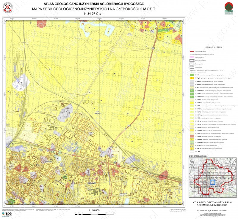
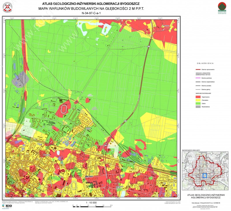
An example of BDGI capabilities - selected thematic maps from the geo-engineering atlas of the Bydgoszcz agglomeration (available for download at: geologia.pgi.gov.pl
Access to geo-engineering data is possible through two map web browser applications operating: Central Geologic Database Portal and GeoLOG. Most of the spatial data are available in a non-editable mode without logging in. Acquisition of editable layers and data from geo-engineering boreholes requires an application to the National Geological Archives (NAG).
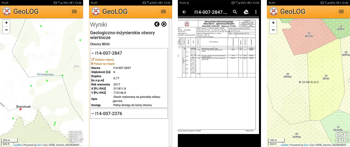
The enormous resources of the geological database, maps and information on PGI-NRI research results, including geo-engineering data are at your fingertips, free of charge and without logging by means of the GeoLOG application, adapted to the touch screen interface of mobile devices
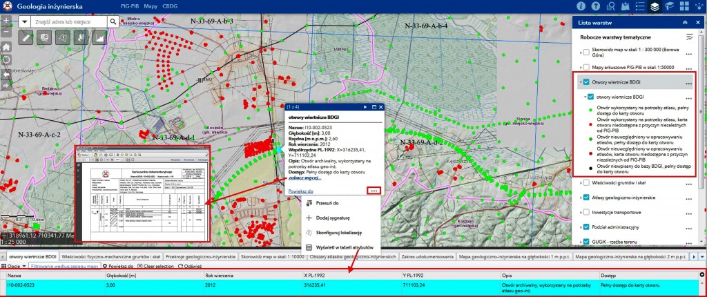
The CBDG Portal. View of the map application (Portal for ArcGIS) showing a layer of geo-engineering wells with descriptive data. The user may conveniently obtain information on metrics of a particular point and its table of attributes, and download a borehole profile as a pdf file (geologia.pgi.gov.pl, tab "Budownictwo")
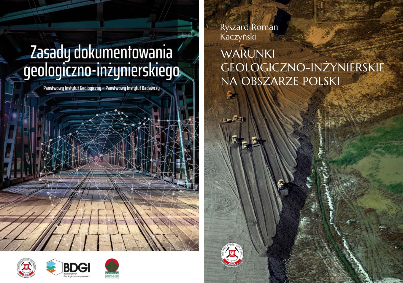
If you are interested in these issues, please visit geoportal.pgi.gov.pl/atlasy, which contains instructions, manuals and guidelines on engineering geology, including Principles of Geo-engineering Documentation and the monograph Geo-engineering Conditions in Poland.
Selected publications available free of charge on PGI-NRI website. More than 15 items are currently available for download
 PGI-NRI offer
 Mineral resources of Poland
  Oil and Gas in Poland


 Subscribe to RSS Feed