


 The level of Poland's energy security is shaped by many factors, one of which is securing the domestic resource base, including hydrocarbons. While shaping the resource policy and conducting exploration and prospecting studies in concession and tender areas it is necessary to have up-to-date geological and resource geology data.
Today the data are scattered among various institutions and at the same time compiled stored in various formats, which may not always meet international standards. The Polish Geological Institute - NRI is currently integrating all available archival geological and reservoir data for hydrocarbon systems from the entire area of Poland. The result of these works is not only verified, digitalized and integrated geological data, but also assessments of prospectivity for hydrocarbon occurrence in a given area.
Integration of geological and geochemical data on hydrocarbon systems of Poland is one of the tasks of the Polish Geological Institute. The task comprises compilation, digitalization and integration of stratigraphic, sedimentological, petrophysical, geophysical, seismic, geochemical, and geological and reservoir data.
The data (digital files in various formats and analogue data) are stored in archival documents and databases at PGI-NRI and at external partners - operators of hydrocarbon concessions. Most data are gathered on the basis of contracts concluded with the leader of natural gas market in Poland - Polskie Górnictwo Naftowe i Gazownictwo SA. Possession of an integrated set of geological and reservoir data makes it possible to quickly access and mutually verify partial data. The use of integrated unified software increases usability of data coming from very different sources, enabling exchange and visualization of data in formats compliant with international standards.
The task is a multi-stage one. The Polish area has been divided into 27 blocks and the work schedule takes into account the priorities of the Ministry of Climate and Environment. An important factor determining the order in which areas are developed is the degree of reconnaissance and the state of advancement in the context of currently anticipated exploration work.
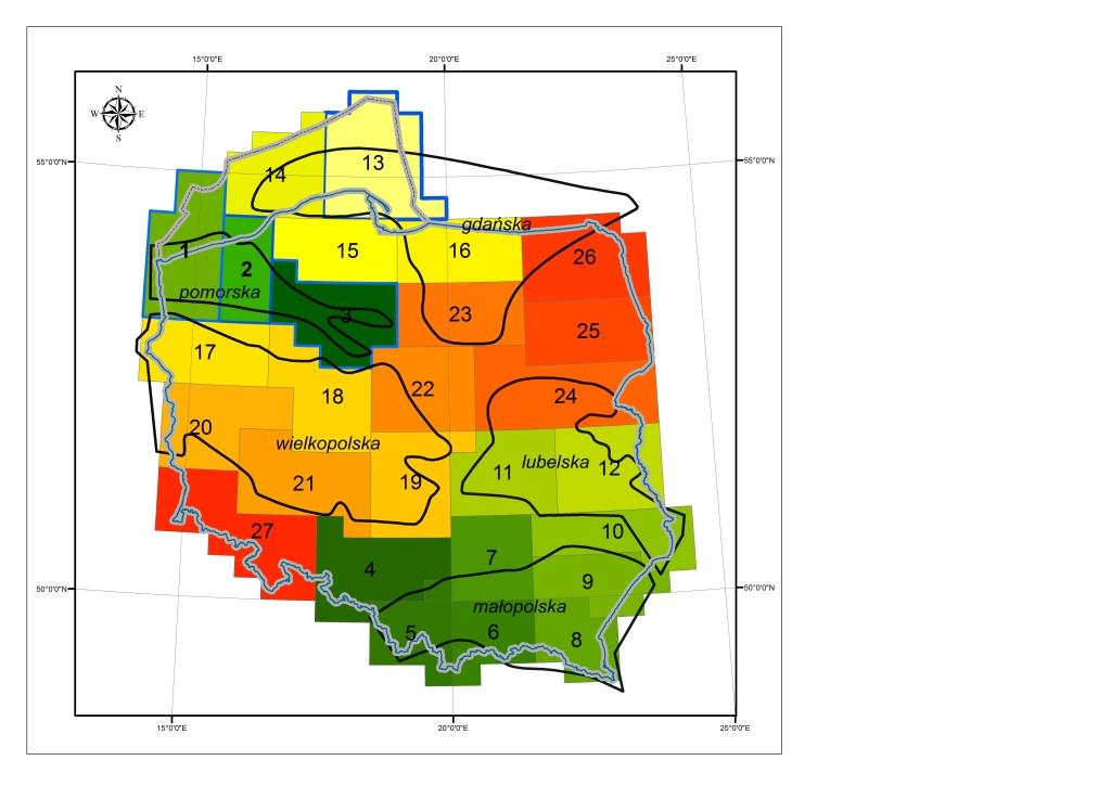
Map of areas covered by work stages of the task "Integration of geological and reservoir data concerning hydrocarbon systems in Poland, their supplementation and analysis in the context of energy security - a continuous task of the Polish Geological Survey"
The task began with work on data for the Pomeranian province, where new hydrocarbon accumulations are currently being discovered and the prospects for further discoveries are significant. The degree of seismic and drilling reconnaissance of the study area varies and the data are scattered throughout multiple institutions. After developing the first pilot area (area 1 on the map), the methodology was revised and now consists of preparing and updating the input data, verifying and integrating the data using an interpretation program, and analyzing the integrated data into a coherent spatial model.
Following this methodology, area no. 2 - covering eastern part of West Pomeranian voivodeship and north-western part of Wielkopolska voivodship (10 hydrocarbon concession blocks) - was completed. During its elaboration tens of thousands of data points were analyzed. In total, 360 seismic profiles, data from 103 wells with depths ranging from 535 m to 5015 m below sea level drilled for the purpose of hydrocarbon exploration and prospecting, 143 seismic horizon floor maps in analogue form derived from 28 geophysical surveys, 781 2D seismic profiles with total length of 216 586.74 km were used.
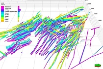
Based on the acquired maps for area 2, digital models of seismogeological surfaces were made, the depth of which is verified by 2D and 3D seismic data. Along with the preparation of the structural surfaces, the process of reconstruction of the dislocation network that disturbs the layering system was carried out. Fault traces from individual surface models after digital processing were compiled first in a 2D space and then in 3D, to obtain a 3D surface model for each fault after combination.
Fault lines used to create a fault model in 3D space - area 2
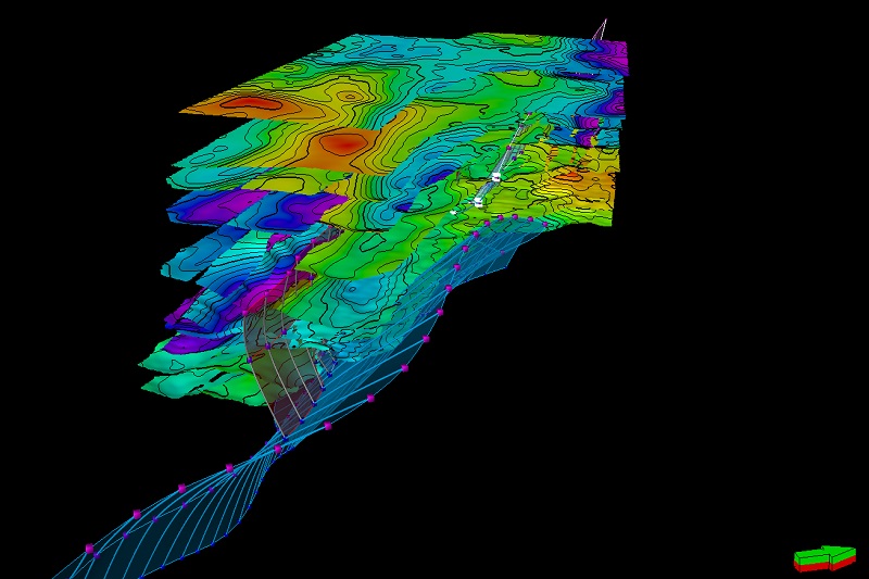
Based on the completed structural model and information from geophysical surveys, three-dimensional parametric modeling was performed for the spatial distribution of total porosity (PHIT), shale volume (VSH), and total organic carbon (TOC).
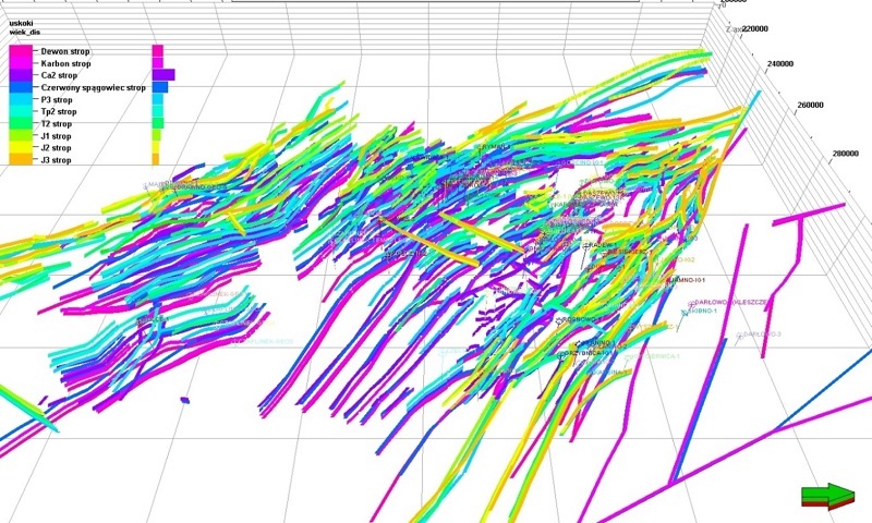
At present, area 3 is being developed, comprising the south-eastern part of the Koszalin - Chojnice tectonic zone, an interesting and still poorly explored geological region with a high potential for discovery of new hydrocarbon fields. It comprises the eastern part of West Pomeranian voivodeship, southern part of Pomeranian voivodeship, central and western part of Kuyavian-Pomeranian voivodeship and northern part of Wielkopolska voivodeship (17 hydrocarbon concession blocks). This is a zone where prospecting is currently conducted and therefore integration of data from several 3D seismic surveys with results of older 2D seismic surveys, as well as geological and reservoir data from wells representative for this area, will provide an unambiguous 3D image of dislocation sequences in the area of conducted studies.
Verification of structural surfaces and fragment of the working version of the fault model in the Unisław region
It is worth stressing that performing the task of integration of geological and reservoir data with observance of a specific procedure in an interpretation project makes it possible to reduce errors and mistakes, and sometimes to correct an already outdated archival interpretation which, apart from updating of geological structure, results in the reduction of exploration risk.
Text: Rafał Laskowicz
Translated by: Tomasz Trzpil
![]()
 PGI-NRI offer
 Mineral resources of Poland
  Oil and Gas in Poland


 Subscribe to RSS Feed