


 In May 2022, a contractor for the first research cruise in the Atlantic Ocean was selected following a public procurement procedure.
The current Agreement provides for a 15-year period for comprehensive environmental research and development of surveying and mining technologies, in accordance with the provisions of the Agreement and ISA regulations.
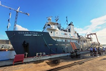
As a result, on July 21, 2022, the Polish Geological Institute - National Research Institute (PGI-NRI), which was entrusted with the implementation of the scientific research service, signed an executive agreement with Canada’s Ocean Floor Geophysics Inc. (OFG).
The conclusion of the contract with the contractor for the first voyage is the culmination of an intensive period of preparation that is also a step towards intensifying Poland's involvement in deep-sea exploration.
From August 10 to September 15, 2022, a team of scientists representing 8 countries and 11 research institutions will conduct key research for the reconnaissance of the Agreement area. In addition to experienced OFG scientists and experts, our country will be represented by specialists from the Polish Geological Institute-NRI and the Ministry of Climate and Environment, as well as researchers from Polish partner institutions such as: the Maritime University of Technology in Szczecin, the Institute of Geological Sciences of the Polish Academy of Sciences, the Institute of Oceanography of the University of Gdansk and the Adam Mickiewicz University in Poznań, who will support the work being carried out with their experience. In addition, the cruise will also be attended by trainees from Tanzania and Bangladesh designated by ISA, which is part of the policy of increasing competence and research capacity of developing countries conducted by this UN agency.
Data acquisition will be carried out using geophysical methods, i.e. a multibeam echo sounder (MBES) for bathymetric analysis, sonar beam scattering intensity (backscatter) analysis to identify "hardness" and "roughness" of the bottom, a sediment profiler (subbottom profiler; SBP - one of two devices in the world operating to a depth of 6,000 m) for the identification of, among other things, faults and escape structures of hydrothermal fluids, and a magnetometer for recognizing changes in the background intensity of the earth's magnetic field related to the thickness of the oceanic crust and the type of deep-sea rocks that make up the bottom. The planned methods will allow parallel data acquisition and data processing and interpretation during the cruise.
The data obtained will allow the identification of morphological structures of ocean bed and the determination of areas predisposed to occurrences of hydrothermal activity, with which the precipitation of massive sulfides are associated.
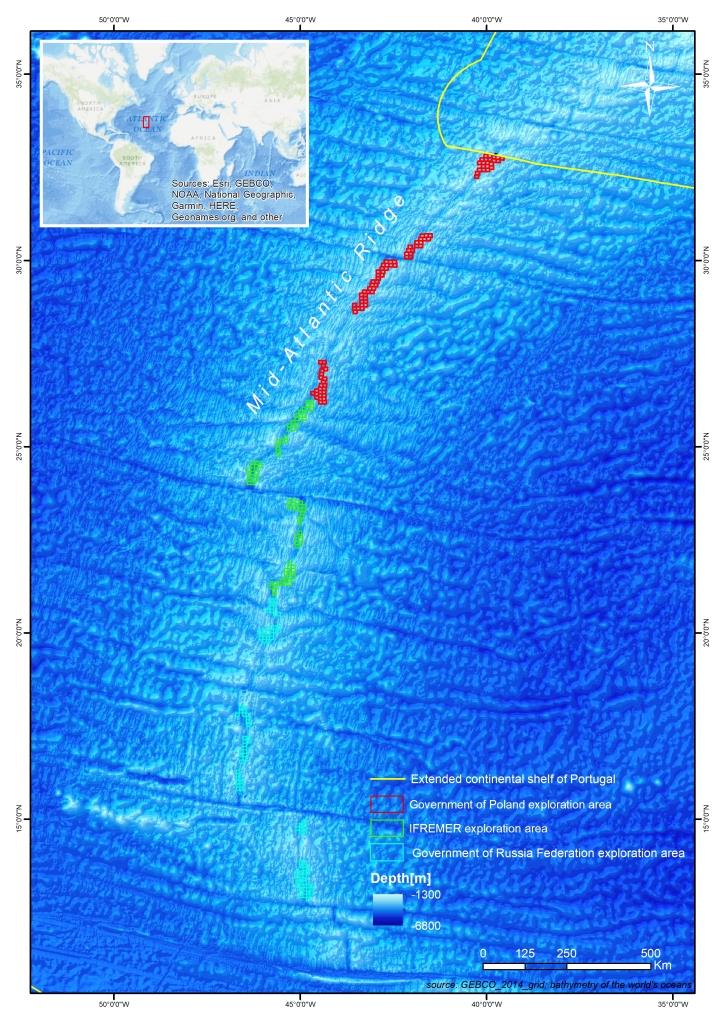
Location of the Polish plot in the Atlantic (Bathymetric map: GEBCO_2014_grid; bathymetry of the world's oceans; by Agata Kozlowska-Roman, PGI-NRI)
In the second phase of the cruise, the selected areas will be studied in detail to identify physical and chemical anomalies (bubbles and gas concentrations, changes in pH and, redox potential, turbidity, etc.) measured with a wide range of sensors and detectors towed in a column of water up to 300 meters above the ocean bed.
Determining sites of hydrothermal activity is key to identifying hydrothermally inactive massive sulfide accumulations with exploitation potential that have been offset from the central ridge axis (off-axis) and buried beneath sediments.
The results obtained will make it possible to plan further survey and research cruises, including AUV/ROV submersibles, and select stations for geological, oceanographic and biological sampling.
The research work carried out will be the first attempt to answer questions about the location of polymetallic resources of hydrothermal origin within the Polish concession located in the Mid-Atlantic. Through the implementation of the planned work, Poland joins the most developed countries of the world, providing a number of unique data on the dynamic processes occurring in the zones of oceanic plate growth, which at the same time will provide an important impetus for the development of science in Poland.
![]()
The expedition is carried out as part of the task "Scientific and research service to search for and identify areas of occurrence of polymetallic massive sulfide deposits on the Mid-Atlantic Ridge" and was financed by the National Fund for Environmental Protection and Water Management (Contract No. 2190/2021/Wn-07/FG-SM-DM/D).
Translated by: Tomasz Trzpil
 PGI-NRI offer
 Mineral resources of Poland
  Oil and Gas in Poland


 Subscribe to RSS Feed