


 A novel approach to cartography, utilizing the latest geological research findings, is a unique feature of the recently developed digital geological map of Poland in an overview scale of 1:500K by Polish Geological Survey. The map consist of three major information layers : classic surficial geological map, pre-Quaternary and pre-Cenozoic maps.
They are published digitally at the PIG-PIB geoportal https://geologia.pgi.gov.pl/ in the a default view of entire Poland.
These three maps represent a pioneering application of GIS digital processing technologies in the context of the overview geological map of Poland. Each map was compiled for one of three consecutive sequences of stratigraphic units:
- Quaternary surface layer (1.8 million years to the present),
- Paleogene and Neogene surface layer (65.5–1.8 million years),
- Sub-Cenozoic surface layers: Neoproterozoic, Paleozoic, and Mesozoic (635–65.5 million years).
The Geological map of Poland at a 1:500,000 scale (MGP 500) comprises three stratigraphic layers: the sub-Cenozoic surface (A), Paleogene and Neogene divisions with the Outer Carpathians (B), and Quaternary divisions (C).
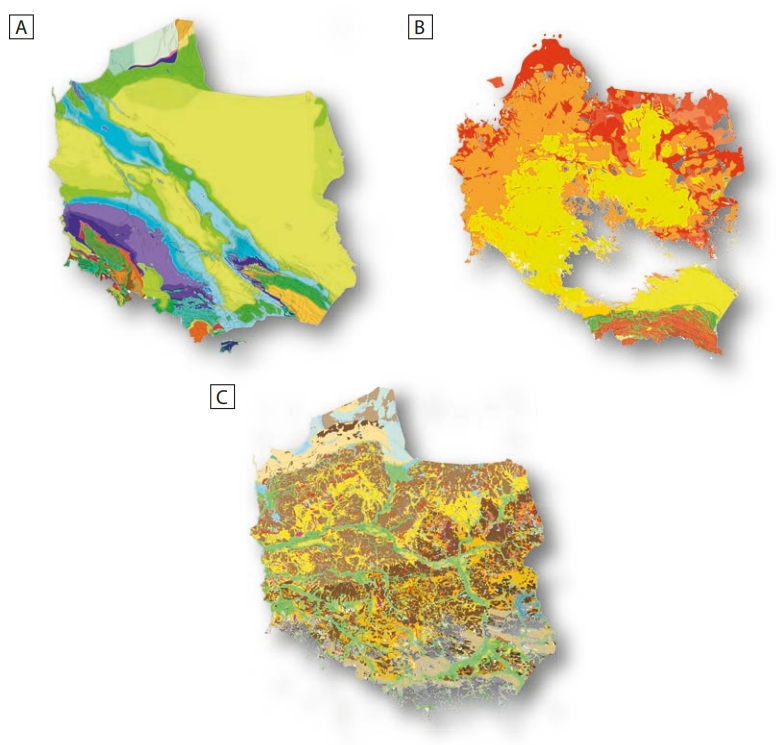
Three stratigraphic layers (packages) that make up the Geological map of Poland at the scale of 1:500 000 (MGP 500) are sub-Cenozoic surface (A), Paleogene and Neogene divisions with Outer Carpathians (B) and Quaternary divisions (C)
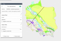
By selecting a random location on the MGP 500 map via the https://geologia.pgi.gov.pl viewer, users gain access to detailed geological information and a range of attributes.
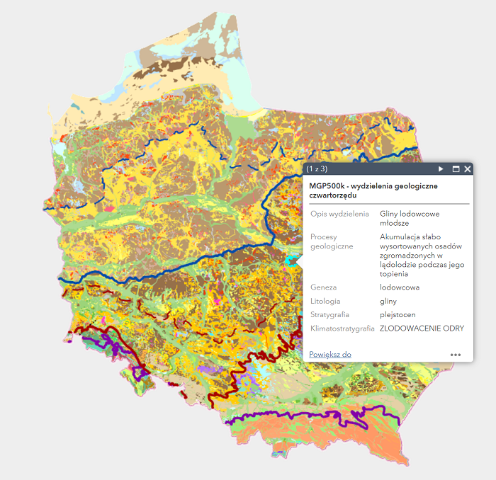
List of division attributes found at the location indicated by the user (the displayed window shows attributes of the first layer – map of Quaternary formations. The ‣ symbol enables displaying attributes from other map layers)
This solution offers numerous additional capabilities, empowering users to conduct spatial analyses and create custom visualizations. Users can generate new maps, such as those illustrating the distribution of specific geological units. Furthermore, users can instruct the map to pinpoint locations of particular rock types, rocks from specific geological periods, or identify the environments and processes responsible for the formation of geological layers.
Below, you'll find the results of sample queries conducted on the https://geologia.pgi.gov.pl website:
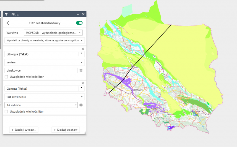
Query 1: Identify sub-Cenozoic geological layers containing marine-origin sandstones.
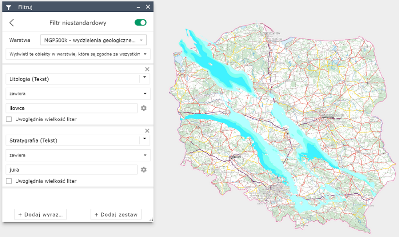
Query 2: Identify sub-Cenozoic geological units containing Jurassic claystones.
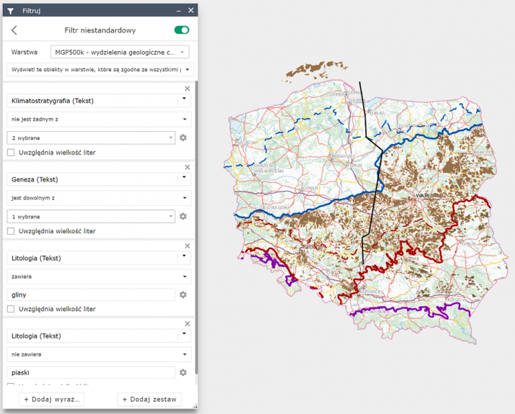
Query 3: Identify Quaternary geological strata formed before the Vistula glaciation, characterized by glacial-origin clays, excluding sands.
The 1:500,000 geological map of Poland, developed as part of the Polish Geological Survey's efforts, is based on an analysis of archival geological data and the latest cartographic research. It integrates data from the Geological map of Poland at a 1:200,000 scale, supplemented by information from the 1:50,000 Detailed Geological Map of Poland (SMGP), as well as geophysical and borehole data.
In addition to geological divisions and boundaries, the maps include data on glaciation extents, glacitectonically disturbed sub-Quaternary surfaces, fault locations, and significant anthropogenic structures. The map's simplicity and exceptional clarity are the result of the collective expertise of a dedicated team of professionals.
The cartographic representation of Poland's geological structure was developed by a team of over 80 specialists, including geologists, cartographers, stratigraphers, geophysicists, and structural geologists.
This new edition of the map is designed for easy display of the country's general geological structure and allows for future updates as new data becomes available. Despite the convenience of GIS processing and the digital accessibility of the map, it is also available in hard copy form, comprising three maps with accompanying explanations and geological cross-sections.
While digital geological maps may tempt users to zoom in for a closer look, both through web browsers like geologia.pgi.gov.pl and GIS applications, it's important to note that the data's accuracy corresponds to the 1:500,000 scale.
The new edition of the Geological map of Poland at a 1:500,000 scale offers a wide range of display and application possibilities. It is accessible on the PGI-NRI website through the map browser at https://geologia.pgi.gov.pl, where users can interact with the map and download PDF versions of the 1:500,000 geological map of Poland (A - surface map, B - sub-Quaternary map, and C - sub-Cenozoic map) along with the explanatory text. We encourage you to explore the map and stay tuned for upcoming articles that will delve deeper into the benefits of these new digital overview maps of Poland.
Entire study
- Marks L., Grabowski J., Stępień U. (red), 2022 – Mapa geologiczna Polski 1:500 000. Państw. Inst. Geol. – PIB, Warszawa. Marks L., Grabowski J., Stępień U. (eds.), 2022 – Geological Map of Poland 1:500 000 (in Polish). Polish Geological Institute – NRI, Warsaw.
Selected elements of the study:
- Marks L., Grabowski J., Stępień U. (red), 2022 – Mapa geologiczna Polski 1:500 000. A – Mapa powierzchni terenu. Państw. Inst. Geol. – PIB, Warszawa.
- Marks L., Grabowski J., Stępień U. (red), 2022 – Mapa geologiczna Polski 1:500 000. B – Mapa podłoża czwartorzędu. Państw. Inst. Geol. – PIB, Warszawa.
- Marks L., Grabowski J., Stępień U. (red), 2022 – Mapa geologiczna Polski 1:500 000. C – Mapa podłoża kenozoiku. Państw. Inst. Geol. – PIB, Warszawa.
- Marks L., Grabowski J., Stępień U. (red), 2022 – Mapa geologiczna Polski 1:500 000. Przekroje geologiczne (A–B i C–D). Państw. Inst. Geol. – PIB, Warszawa.
- Marks L., Grabowski J., Stępień U. (red), 2022 – Mapa geologiczna Polski 1:500 000. Tekst objaśniający. Państw. Inst. Geol. – PIB, Warszawa.
Text: Urszula Stępień, Anna Bagińska
 PGI-NRI offer
 Mineral resources of Poland
  Oil and Gas in Poland


 Subscribe to RSS Feed