


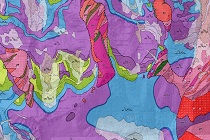
 We encourage you to familiarise yourself with digital geological maps of Poland recently compiled by PGI-PIB in the scale 1:500,000 - a surface map (covered) and two uncovered maps - without Quaternary and Cenozoic formations.
The new edition of the Geological Map of Poland on a scale of 1:500 000 opens up many possibilities for its presentation and use.
The map is available on the PIG-PIB website at the map browser https://geologia.pgi.gov.pl, where it is possible to view both its interactive version and download pdf files of Geological Map of Poland 1:500,000 (A - map of land surface, B - map of Quaternary and C - map of Cenozoic subsoil) together with explanatory text.
In fulfilment of the tasks of the Polish Geological Survey, the Polish Geological Institute - PIB is working on the preparation of a new system for external stakeholders for the provision and publication of geological maps called the “Common Platform for Geological Cartography”. We plan to make geological maps available in both raster (image files, map scans) and vector (packages, GIS databases) versions and as continuous spatial data layers.
 PGI-NRI offer
 Mineral resources of Poland
  Oil and Gas in Poland


 Subscribe to RSS Feed