


 As part of preparations for collaboration with the Geological Survey of Sweden (SGU), the Polish Geological Institute (PGI) has published their latest 3D geological map of the Malmö and Lund area using the Geo3D web viewer, a platform developed in-house at PGI.
It’s definitely worth exploring. The map is available at the following link: https://geo3d.pgi.gov.pl/Malmo_GH_80m/index.html
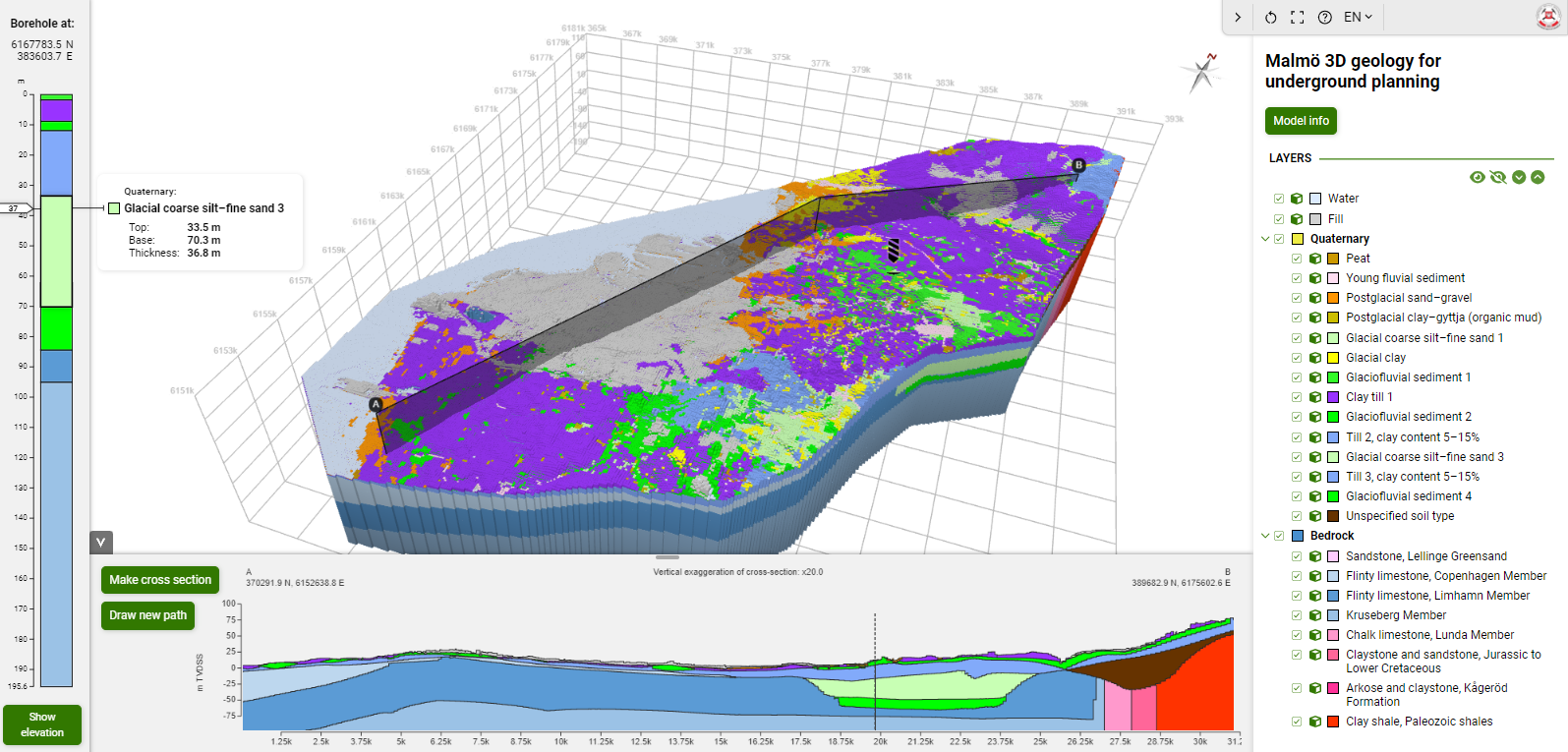
This map was created to support spatial planning, infrastructure development projects, and the management and protection of local resources, particularly groundwater reservoirs.
This interactive visualization, developed at the request of Swedish geologists, highlights Geo3D’s potential for presenting the results of their work. This project is a prelude to a collaboration that could lead to using Geo3D for presenting all 3D geological maps and models produced in Sweden over the years.
The SGU team recognizes the importance of effectively presenting geological research results to local communities in an intuitive way, as offered by Geo3D. Thanks to this tool, municipal officials, construction companies, and local residents can explore the geology of their area using only a web browser on a computer or even a smartphone.
Geo3D allows users to explore layers by creating geological cross-sections, drilling virtual boreholes, or split apart individual layers or entire complexes. The viewer enables examination of layers depth and thickness.
The presented 3D geological map of Malmö and Lund showcases anthropogenic deposits, Quaternary glaciofluvial sediments, and the bedrock consisting sedimentary rocks of the Danish Basin (Triassic–Paleogene) overlying older Paleozoic rocks (Silurian) and Scandinavian crystalline basement. The Quaternary sands and gravels, which form the main groundwater reservoirs, have been mapped in detail in 3D to ensure their sustainable use and protection.
Below is a short video showcasing the Malmö and Lund 3D geological map in the Geo3D web viewer, an increasingly popular product from PGI.
Text: Zbigniew Małolepszy
 PGI-NRI offer
 Mineral resources of Poland
  Oil and Gas in Poland


 Subscribe to RSS Feed