


 We know where the inferred boundary between the Jurassic - Oxfordian and Kimmeridgian stages runs.
In February of this year, the International Union of Geological Sciences ratified an application of the Kimmeridgian Group of the International Subcommission on Jurassic Stratigraphy for its delineation in the profile of Flodigarry, located on the Isle of Skye, Scotland. An interview with the Chairman of the Kimmeridgian Group, Prof. Andrzej Wierzbowski, PhD, and the co-author of the proposal, Hubert Wierzbowski, PhD (the coincidence of their names is not accidental) about the research that led to the inferred model and its significance for geology.
The golden spike, or GSSP benchmark, in geology is...
Hubert Wierzbowski (Polish Geological Institute-PIB): The almost proverbial "golden spike" is a precisely defined benchmark point located at a boundary between geological stages, which can also define, due to its location, a boundary between systems, e.g. Triassic and Jurassic or erathems, e.g. Paleozoic and Mesozoic. As of 1977, it has been standardized and officially registered by the International Commission on Stratigraphy of the International Union of Geological Sciences in standardized profiles of sediments, mainly marine and referred to as GSSP - Global Boundary Stratotype Section and Point, which may be loosely translated as the world standard - geological stratotype boundary located at a particular point of a selected geological profile.
GSSP benchmarks are determined mainly based on faunal indicators, i.e. fossils. This method is based on changes in the world of organisms due to evolution. Moreover, geochemical indicators play an important role, e.g. changes in isotopic composition of rocks, palaeomagnetic indicators, i.e. changes in past directions of rock magnetization or radiometric dating. They should be easily identifiable in the available standardized profiles, independent of changes in rock formation and, based on the observed changes, identifiable in other areas of the world, and thus be of global character.
Recently, the golden spike was hammered into...?
Hubert Wierzbowski: Two weeks ago, on February 15th, 2021, the International Union of Geological Sciences ratified an application to delineate the GSSP benchmark boundary between the Oxfordian and Kimmeridgian, of the Upper Jurassic in the Flodigarry profile on the Isle of Skye, Scotland. The application was prepared by the Kimmeridgian Group of the International Subcommittee on Jurassic Stratigraphy. In the model profile of Flodigarry, in the coastal intertidal zone, there are well exposed clay rocks with subordinate interbedding of limestone (photos 1, 2, 3).
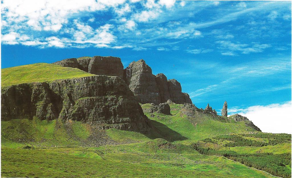
Photo 1. Overburden rocks of the Flodigarry profile on the Isle of Skye, Scotland (including a sharp rock - the so-called "Old Man of Storr"). Author: A. Wierzbowski
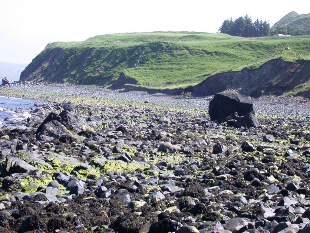
Photo 2. Intertidal zone with Oxfordian and Kimmeridgian outcrop (Upper Jurassic) rocks in the Flodigarry profile on the Isle of Skye, Scotland. Authors: A. Wierzbowski
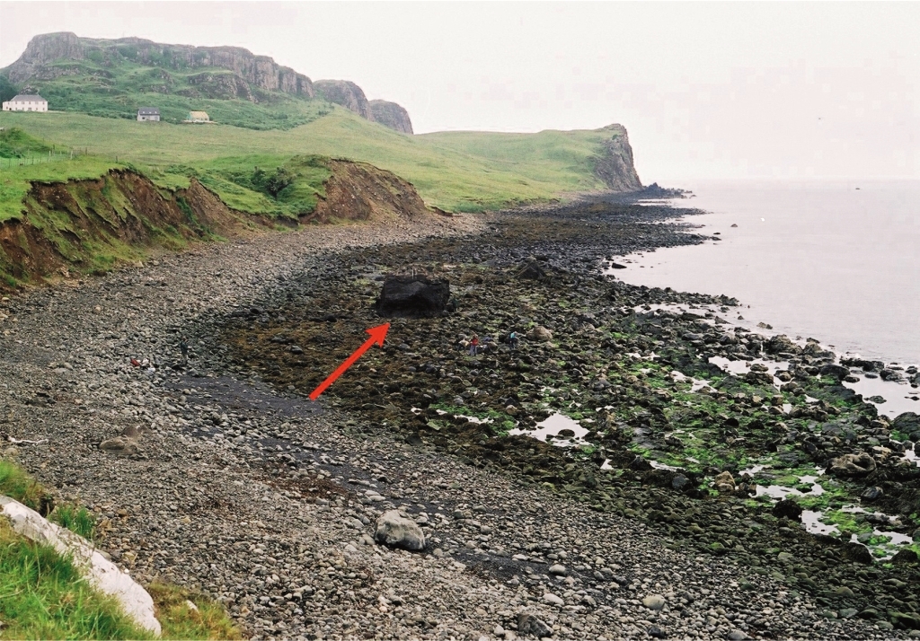
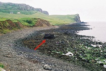
Photo 3. Intertidal zone with Oxfordian and Kimmeridgian outcrop (Upper Jurassic) rocks in the Flodigarry profile on the Isle of Skye, Scotland (an arrow marks the location of the Oxfordian and Kimmeridgian boundary). Author: A. Wierzbowski
The proposal included a detailed description of the Flodigarry profile, including a description of the stratigraphic succession of the ammonite fauna, which are the key fossils for the dating of the Jurassic sediments. In addition, they indicate changes in the distribution of microfossils, isotopic composition of stable oxygen and carbon isotopes, and paleomagnetism of the rocks, as well as age correlates of the age of this profile with exposures from different areas of the world.
The point corresponding to the boundary of the Oxfordian and Kimmeridgian stages has been precisely delineated, within the upper part of 35th layer of the Flodigarra profile, mainly based on a significant change in the ammonite fauna, but also based on geochemical changes and palaeomagnetic properties. In the future, during an official ceremony with local authorities, a symbolic "golden spike" will be placed there and the location of the boundary will be documented geodetically.
Is the established geological boundary of two Upper Jurassic strata – the Oxfordian and Kimmeridgian - visible to the naked eye or must it be determined by geological methods?
Hubert Wierzbowski: The GSSP benchmark boundaries should by definition not correlate with often local changes of rock types occurring in a given profile, but should be established on the basis of the aforementioned geological indicators, e.g. fossil assemblages in geological profiles, which were characterized by continuous, slow sedimentation, and thus can be established in rather monotonous rock series. In the Flodigarry profile, the point corresponding to the aforementioned boundary can be precisely determined within a rather uniform silt layer 35, by measuring about 1.25 m from its top, which is located under the characteristic limestone layer 36 (photo 4). Thus, the established boundary can also be seen in a certain sense, although it is not expressed by a change in rock type and features. In other geological profiles this boundary may be established in completely different rock types.
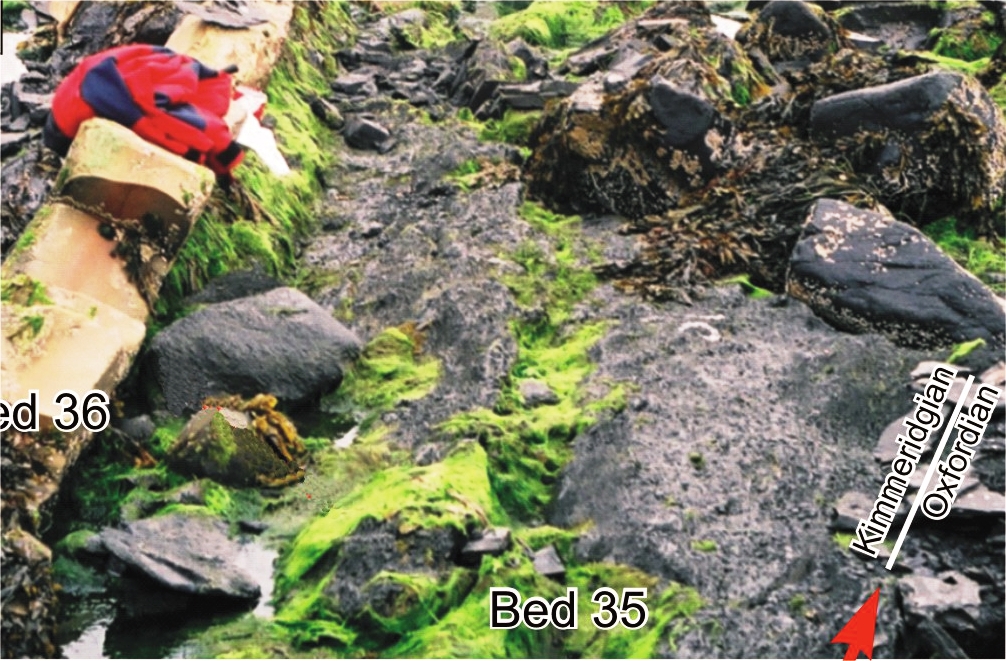
Photo 4. Point showing the precise location of the boundary between the Oxfordian and Kimmeridgian in the upper part of layer 35. Author: B. Matyja
The results of which research decided that this very site in Scotland was indicated as the most representative on Earth for the boundary between the Oxfordian and Kimmeridgian?
Andrzej Wierzbowski (Chairman of the Kimmeridgian Group, retired employee of the Polish Geological Institute-PIB): Although the Oxfordian and Kimmeridgian stages of the Upper Jurassic were distinguished over 200 years ago, their boundary was first palaeontologically specified in 1913 based on changes in ammonite assemblages observed on the Dorset coast in southern England. Ammonites from this area belong to the northern (boreal) ammonite group and are typical throughout northwestern Europe and much of the Arctic.
Because the profiles of southern England were characterized by incomplete geological record and existence of time (stratigraphic) gaps, they did not meet the recommendations of the GSSP benchmark and another profile with similar ammonite fauna had to be found, which met all the requirements. On the other hand, Arctic areas - such as Greenland or Siberia do not meet the conditions of easy availability of the benchmark.
The only profile that meets all the requirements of a GSSP benchmark is that seen on the Isle of Skye in northern Scotland. This profile is located at the base of a cliff, in the zone of tidal influence, which, although it limits access to some extent, on the other hand provides, permanently, a good exposure of the rocks occurring here, as the fine rock debris is not deposited around the exposure, but is removed by strong currents at low tide.
The Flodigarry profile on the Isle of Skye, Scotland is the only relatively accessible profile that meets the other basic conditions to become a GSSP benchmark. It contains abundant, well-preserved, fossils of extinct cephalopods: ammonites and belemnites, as well as calcareous and organic microfossils allowing precise determination of the stratigraphic succession of the fauna and studies of the isotopic composition of stable calcium carbonate belemnite skeletons. In addition, the rocks there, mainly dark silt and shale, have preserved the original record of changes in the past orientation of the Earth's magnetic poles, used in palaeomagnetic dating.
Moreover, it is important to be able to make broad comparisons of changes in ammonite faunal assemblages of this profile with assemblages from other parts of Europe and the world, partly on the basis of so-called auxiliary profiles, and thus to determine the exact age equivalent of the accepted Oxfordian-Kimmeridgian boundary benchmark in other areas.
What are the differences in sediments of these two stages?
Hubert Wierzbowski: During the Oxfordian and Kimmeridgian, very different sediments were deposited in different geographical zones. For example, in Scotland, which belongs to the northern (boreal) faunal-geographic provinces in the Jurassic, it was mainly dark silt and shale sediments with single overburden layers and calcareous concretions.
In the area of central and southern Poland, then belonging to the southern (Mediterranean) provinces, during the Oxfordian and early Kimmeridgian first deep-water and then shallow-water calcareous and calcareous-marly sediments were deposited, which make up the picturesque rocks of today's Kraków-Częstochowa Upland, also called the Polish Jurassic Highland. They are also exposed or occur close to the surface in the south-western and south-eastern fringes of the Holy-Cross Mountains and the southern part of the Łódzkie Voivodship as well as in Kuyavia. They are of significant economic importance for the construction and cement-lime industries.
The Upper Kimmeridgian formations for the most part are not preserved or do not occur on the surface in central Poland, but are known from boreholes in its northern part, where they are developed as dark silt-shale sediments. Thus, there is a clear change in the type of rocks which has nothing to do with the dating of age limits of geological units.
What does the establishment of GSSP benchmarks mean for geology?
Hubert Wierzbowski: GSSP benchmarks are of great importance for geologists, because they define precisely the boundaries to which they should correlate their studies, when describing geological profiles, including drill cuttings, geological structure of given regions or creating geological maps. This is aimed at unifying the divisions and dating of rocks in the world, in order to avoid confusion related to local nomenclature and units, which were often used, for example, in past geological studies and are still used in some places.
The example of the former division of the Jurassic in Germany can be given here, where they were not based on age, but instead were divided into lithological units marked by letters of the Greek alphabet, which were difficult to understand for foreign researchers. Another example is the lithological-age units called "svity" used by Soviet and Russian researchers.
The use of GSSP benchmarks, therefore, forces researchers to analyze in detail the criteria for demarking boundaries by identifying those best suited for broad stratigraphic correlations and by making corrections to existing divisions.
Does the adoption of the benchmark entail the necessity of changes - for instance in geological maps of Poland?
Andrzej Wierzbowski: The adoption of the global benchmark for the boundary between the Oxfordian and Kimmeridgian horizons eliminates significant divergence of regional divisions that is particularly significant between the north and south of Europe (i.e. areas of former Boreal and Mediterranean provinces), and thus clarifies stratigraphic division of the Upper Jurassic. This is of great importance for the dating of Upper Jurassic rocks, the delineation of stratigraphic units and the creation of geological maps.
This makes it necessary to update geological maps and divisions of the Jurassic in Poland, where the currently accepted boundaries of the Oxfordian and Kimmeridgian will be significantly shifted towards older strata. For example, the picturesque limestone rocks of the Kraków-Częstochowa Upland and Wieluń Upland, so far classified as the Oxfordian stage of the Upper Jurassic, should now be identified as partly Lower Kimmeridgian.
The research that established the accepted benchmark took over 20 years. Is that a long time, or is it typical for this type of research?
Andrzej Wierzbowski: The time needed to establish a GSSP benchmark depends on many factors and usually takes a while. This is due to the complexity of the issue of delineating such a benchmark, the research conducted and the activity of the work group, and the duration of the approval procedure.
In the case of defining the boundary between the Oxfordian and Kimmeridgian (actually the lower boundary of the Kimmeridgian, because GSSP patterns define only the lower boundary of the defined stage), the problem was quite complex. This is because in the past an error was made in the correlation of the Oxfordian and Kimmeridgian boundary identified in England (and thus northwestern Europe and the Arctic areas) and the rest of Europe. Around 1950 an erroneous identification of the ammonite assemblages of northern and southern Europe as coeval, represented in fact by distinct fossil assemblages developing at different times. This error was recognized in two independent publications from 1997 - one from Poland, the other from southern Germany. In both, the occurrences of ammonites of northern and southern origin was analyzed and it was shown that the Oxfordian and Kimmeridgian boundaries are distinctly higher in the southern part of Europe - by about two ammonite levels (corresponding to about 1-1.5 Ma) than in the north.
As a result, there were (and in fact still are today) two unofficial boundaries recognized as the boundary between the Oxfordian and Kimmeridgian, which greatly differ from each other (although geologists were not fully aware of it) - in northern and southern Europe. With respect to the Jurassic stages, this was perhaps the greatest identified error in the stratigraphic divisions used, which further demonstrated the validity of identifying a universal GSSP benchmark.
The activities of the Kimmeridgian group, in addition to the development of the GSSP benchmark on the Isle of Skye, therefore had to be extended to include activities in other areas of Europe, in order to correctly carry out the correlation between northern and southern areas on the continent. As part of this work, complementary surveys of additional profiles were carried out, primarily to investigate the assemblages of ammonite faunas crucial to carrying out the correlation.
Such surveys were carried out at three sites in Europe: in northern Russia near the village of Mikhalenino near the town of Makar'ev (Kostroma region; photo 5), in central Poland at the village of Bobrowniki in the Wieluń Upland (photo 6), and in central Spain near the village of Fuentelspino de Moya near the town of Landete (Castilla region; photos 7-8).
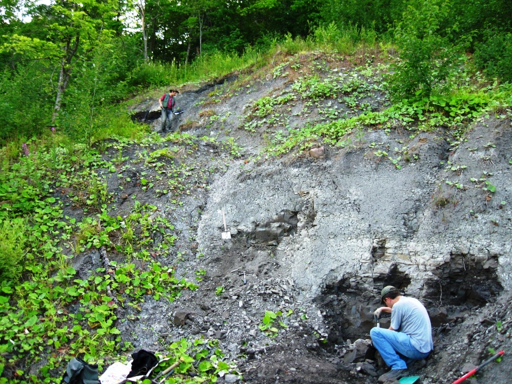
Photo 5. Field work in an auxiliary profile of the Oxfordian and Kimmeridgian border from northern Russia near the village of Mikhalenino near the city of Makar'ev (Kostroma Oblast). Author S. Malenkina
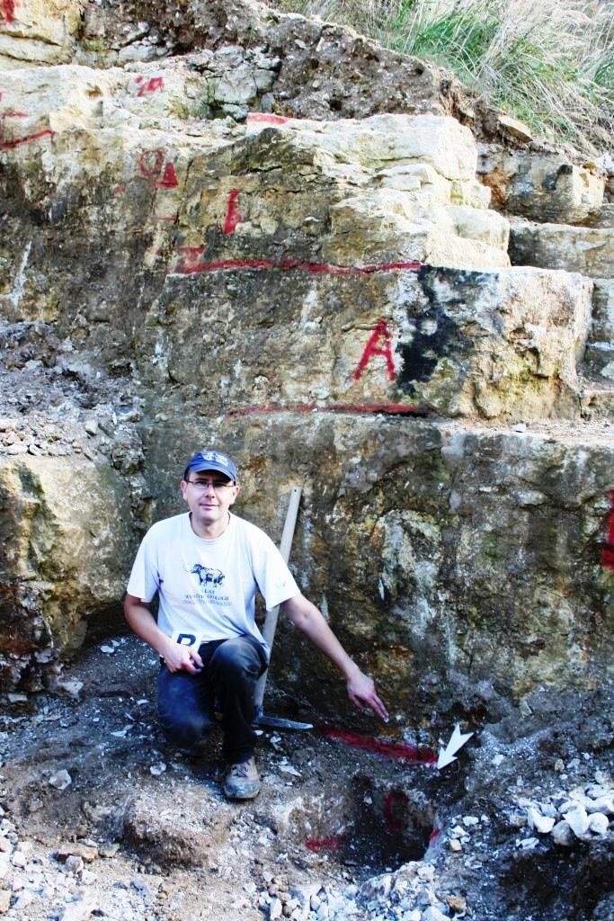
Fig. 6. The location of the Oxfordian and Kimmeridgian boundary in the auxiliary profile of Bobrowniki in the Wieluń Upland (central Poland). Author A. Wierzbowski
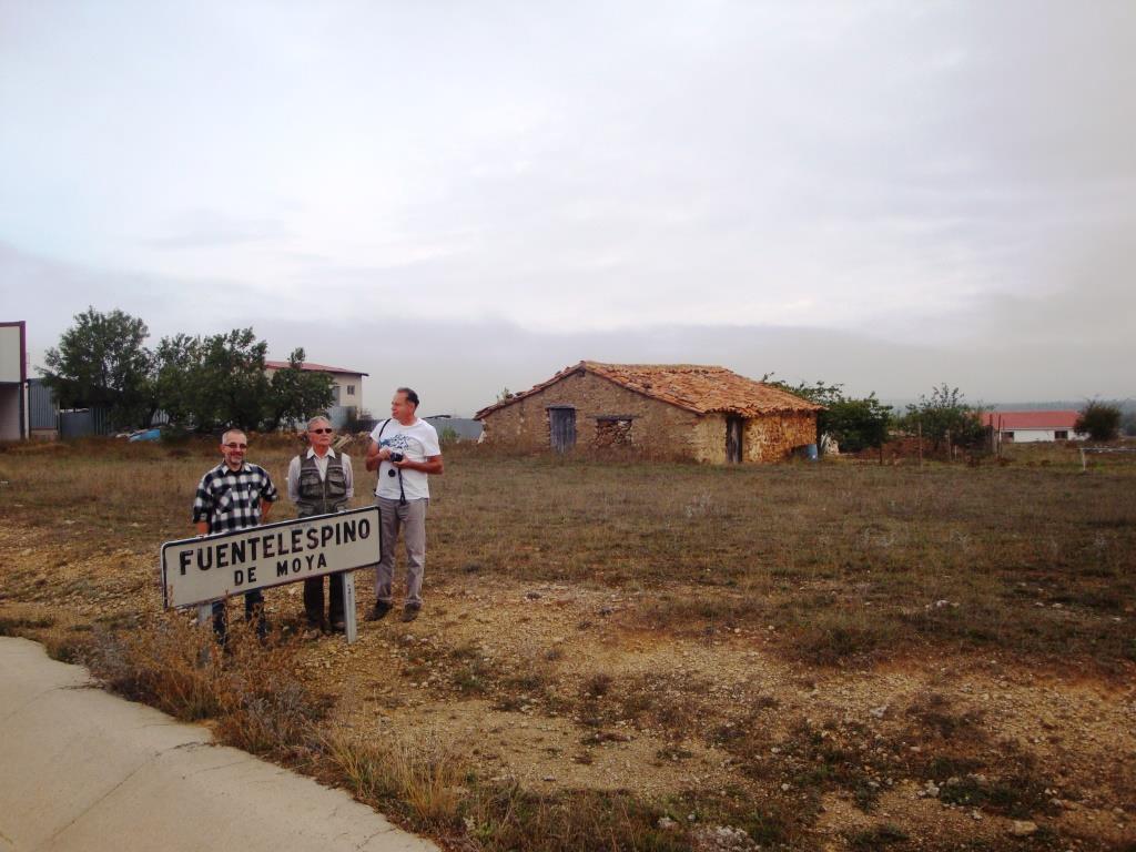
Photo 7. Field work in the auxiliary profile of the Oxfordian and Kimmeridgian boundary of Fuentelspino de Moya near Landete (Castile region, central Spain). Author: A. Wierzbowski
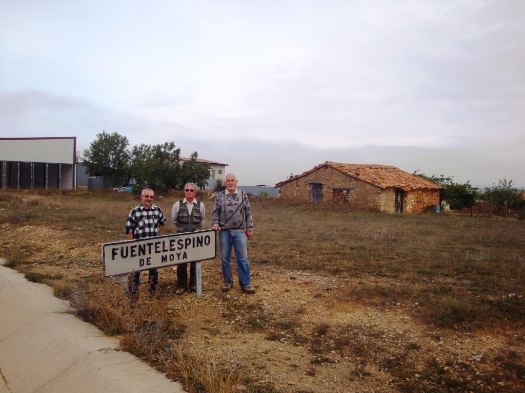
Photo 8. Field work in the auxiliary profile of the Oxfordian and Kimmeridgian boundary of Fuentelspino de Moya near Landete (Castile region, central Spain). Author: T. Sztyrak
In addition to palaeontological studies, other studies were carried out in the above-mentioned profiles by geologists of various specializations, all of which had to be agreed with each other and at least partly published.
Apart from palaeontological studies, other studies were carried out in the above mentioned profiles by geologists of various specializations and all of them had to be agreed upon and at least partly published.
Also the application approval procedure at successive levels required discussions and sometimes amendments. Taking all this into account, as well as the fact that some other stages of the Jurassic system (e.g. Callovian, Oxfordian, Tithonian), as well as the boundary of the Jurassic and Cretaceous systems have not lived to see the final development and approval of the GSSP applications to this day, the time that elapsed from the beginning of the Kimmeridgian group until the approval of the benchmark was not that significant.
The research was conducted by an international team of researchers from Poland, Great Britain, Russia, Germany, France, Spain and the USA. What was the participation of Polish geologists?
Andrzej Wierzbowski: As I mentioned, the proposal was developed by the Kimmeridgian work group of the International Subcommission on Jurassic Stratigraphy, of which I had the pleasure to be the chairman of. The proposal was prepared by a team of authors from many countries in cooperation with PIG-PIB staff members Hubert Wierzbowski, PhD and Jacek Grabowski, PhD.
Marcin Barski, PhD and Prof. Bronisław Andrzej Matyja, PhD of the Faculty of Geology, University of Warsaw, also took part in the preparation of the application. 21 geologists of various specializations from different countries actively participated in the work group. The final conclusion was prepared by nine authors and additionally supplemented by twelve auxiliary authors whose contribution was more limited.
It is worth noting that the leading role in the overall consideration and correlation of central Europe was played by the Polish profiles from the Wieluń Upland, whose stratigraphic study is included in the proposal.
Could it be that in the future, geological studies will provide us with new information and the golden spike for the Oxfordian and Kimmeridgian boundary will be driven in a different place?
Andrzej Wierzbowski: Of course it is possible, although unlikely. Each stage of research and the results achieved by the Kimmeridgian work group were presented at international scientific symposia and congresses, and the results were widely discussed and published in partial publications, so they were subject to verification by the whole geological community the entire time.
The final proposal of the working group was initially voted on within the group itself, where it had to achieve at least 66% of positive votes. The further procedure consisted of a vote of the prepared proposal by the members of the International Jurassic Stratigraphy Subcommittee, and then by the members of the International Commission on Stratigraphy, and finally the proposal was approved by the International Union of Geological Sciences.
We can boast that in all these votes our proposal received 100% positive votes.
How many golden nails have been hammered into the stratigraphic table so far?
Hubert Wierzbowski: To date, about 70 GSSP benchmarks have been designated and accepted. About 40 benchmarks are in various stages of development or awaiting acceptance and ratification.
The status of designating benchmarks can be followed on the International Commission on Stratigraphy website (stratigraphy.org).
Do we have a designated GSSP boundary in Poland, i.e. a hammered-in golden spike?
Hubert Wierzbowski: Unfortunately, we don't, although there is one proposal for the lower boundary of the Coniacian stage of the Upper Cretaceous. On the other hand, closest to Poland are three GSSP benchmarks for the Silurian and Devonian strata delineated in the Czech Republic, including the boundary of both these systems.

Prof. Andrzej Wierzbowski, PhD graduated from the Faculty of Geology, University of Warsaw; Ph.D. 1965, D.Sc. 1977, Prof. 1995; in the years 1967-2011 employed by the Faculty of Geology, University of Warsaw, as Assistant Professor; Director of the Institute of Fundamental Geology (1981-84), Deputy Dean of the Faculty (1984-87), Deputy Head of the Interdepartmental Studies on Environmental Protection (1993-96), Head of the Department of Dynamic Geology (until 2009). In 2011-2016 employed by the Polish Geological Institute - National Research Institute. Scientific activities mainly related to stratigraphy, palaeogeography, sedimentology and palaeontology of the Jurassic system; outside Poland, conducted scientific work in Cuba, Spitsbergen and various parts of Europe (Scotland, Slovakia, Ukraine, Russia, Spain), participated in the development of drilling in the Barents Sea and Norwegian Sea. Author of over 300 publications, editor-in-chief of the journal "Volumina Jurassica". Part of the office of the International Subcommission on Jurassic Stratigraphy (1996-2008) and chairman of the Kimmeridgian work group (since 2000).

Hubert Wierzbowski, Ph.D., Professor at the Institute, graduated from the Faculty of Geology, University of Warsaw, 2002, Ph.D. in 2011, in the years 1997-2013 employed at the Institute of Geological Sciences, Polish Academy of Sciences, in the positions from assistant to associate professor, head of the Department of Stratigraphy and Palaeogeography (2006-2008); since 2013 employed at the Polish Geological Institute - National Research Institute, successively in the positions of senior specialist, associate professor, and currently professor at the Institute. Scientific activities connected with geochemical studies, palaeoclimatology and sedimentology of Jurassic and Cretaceous sediments, as well as geochemistry of fossils composed of calcium phosphate of various ages. Manager and contractor of research projects based on materials from Poland, Russia, Slovakia, Scotland and Ukraine. Author of numerous publications, including 27 published on the so-called "Philadelphia List". Numerous publications on palaeoclimatology and isotopic stratigraphy of the Upper Jurassic. Since 2006 member of the Kimmeridgian work group of the International Subcommission on Jurassic Stratigraphy.
Translated by Tomasz Trzpil (PGI-NRI)
 PGI-NRI offer
 Mineral resources of Poland
  Oil and Gas in Poland


 Subscribe to RSS Feed