


 The simultaneous comparisons of many cartographic publications and tracing of the development of geological structure concepts in a selected region are among many possibilities offered by the new online application presenting historical geological maps of Poland.
The test version of the new portal, which is a part of the Polish Geological Cartography Platform (pol. Wspólna Platforma Kartografii Geologicznej – WPKG) was presented by Katarzyna Jóźwik from the PGI-NRI Geological Mapping Department during the Polish Geological Society Meeting, held remotely on June 24, 2021.
The discussion of the most important application functions, together with an online demonstration, was a part of a lecture titled "Historical geological maps of Poland and surrounding areas and their presentation on the web pages of the Polish Geological Society (pol. Polskie Towarzystwo Geologiczne – PTG) and PGI-NRI" by Dr. Eng. Piotr Krzywiec (ING PAN Prof.), Dr. Stanisław Wołkowicz (Prof. PIG-PIB), Dr. Rafał Sikora (PIG-PIB), Katarzyna Jóźwik (Prof. PGI-NRI), Dr. Rafał Sikora (PGI-NRI), Katarzyna Jóźwik (PGI-NRI), Marek Adamski (PGI-NRI) and Dr. Krystyna Wołkowicz (PGI-NRI). The WPKG project is being carried out at the Polish Geological Institute-NRI as one of the tasks of the Polish Geological Survey.
The test version of the application consists of two parts. The first presents the Geological Atlas of Galicia in the scale of 1:75,000, the second - other valuable geological maps in various scales and spatial extent. Each part contains a short note about the publication itself (including the history of its origin) and basic information on particular maps and map sheets (including the author of the work, name, year of compilation, scale, publisher and printing). A legend for each map is also available.
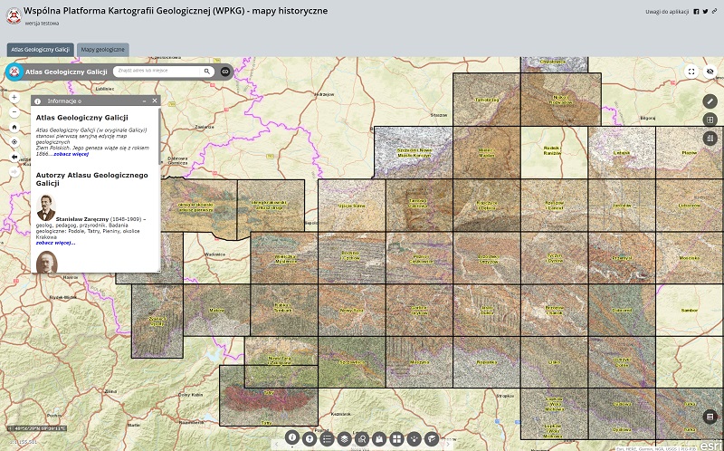
Screenshot of the test version of the Polish Geological Cartography Platform - historical maps application. Tab with the Geological Atlas of Galicia
The "Polish Geological Cartography Platform (WPKG) - historical maps" application offers the opportunity to see the oldest geological map of Poland, compiled by Jean-Étienne Guettard and published in 1764, the "Carte mineralogique de Pologne". The test version of this application was created for this year's celebrations of 100th anniversary of the Polish Geological Society and the historical geological maps presented come from the PGI-NRI public resources, as well as from private collections of Piotr Krzywiec and Stanisław Wołkowicz and Krystyna Wołkowicz.
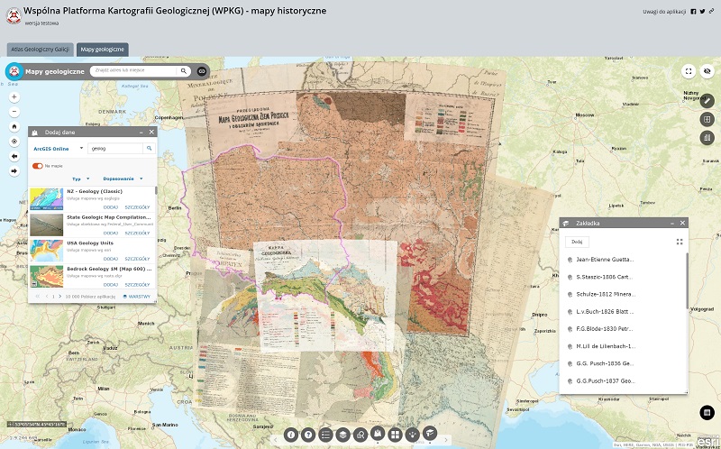
Screenshot of the test version of the Polish Geological Cartography Platform - historical maps application. Tab with other geological maps
The application contains many useful functions. For instance, selected historical maps may be overlaid with the contemporary Geological Map of Poland without Cenozoic formations in the scale of 1: 1,000,000. There is also an option of comparing data by means of managing transparency and smoothly revealing or covering selected layers. It is also possible to overlay contemporary data from geosites, caves and deep boreholes, as well as administrative divisions of Poland (by province), onto historical maps. It is also possible to search and upload geological data from all over the world - provided that they are available in ArcGIS Online resources.
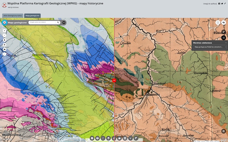
Test version of the application Polish Geological Cartography Platform - historical maps gives the opportunity to compare older cartographic publications with current data
The application is intuitive in use also thanks to a dedicated search engine, where the query criteria are: the name of a map or a map sheet, its author or the compilation year. You can save the resulting data view, as well as your own map composition (e.g. selected maps displayed with an appropriate transparency) and, using an automatically generated link, return to them at any time, send a link to the ready composition to your friends or co-workers or share it in social media. You can also embed a specific map view with a prepared composition or query result as an interactive map on your own website.
Until August 31, 2021, there is an opportunity to test the application. Comments and suggestions on its content and functioning can be submitted to This email address is being protected from spambots. You need JavaScript enabled to view it..
Link to application: https://arcg.is/0WLOWm0
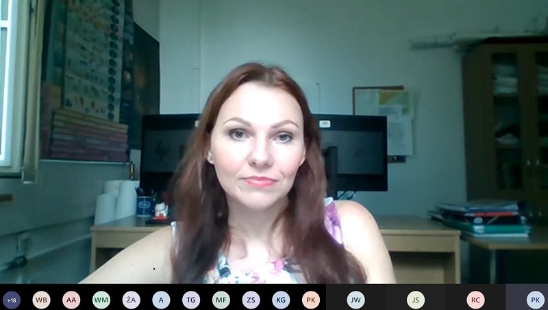
The Project Manager for the "Creation of the Polish Geological Cartography Platform" project, Katarzyna Jóźwik from the PGI-NRI Geological Mapping Department introduced the most important functions of the test version of the application that presents historical geological maps. The meeting was held remotely on the MS Teams platform
About the "Polish Geological Cartography Platform" project
The aim of the "Creation of the Polish Geological Cartography Platform (WPKG)" project is to integrate Polish geological cartography resources through their systematization, organization and gathering in a collective data resource (i.e. GIS database and file repository) and then making them available through a specially designed application/map browser. By the end of 2023, a total of about 20,000 cartographic products in the form of image and text files, as well as spatial data services, will be collected and made available as part of the WPKG project. The Polish Geological Cartography Platform will combine both the newest cartographic products and archival geological maps developed by PGI-NRI and other scientific institutions over the last decades. This solution will provide user-friendly tools for searching, analyzing and downloading data and will enable the parallel use of data from multiple other sources.
The Polish Geological Cartography Platform will contain not only digital maps, but also a lot of useful information, e.g. on rock lithology, age and genesis. It is planned to equip the application with functions for performing various spatial analyses, as well as the ability to direct simple and complex queries to the database. This will make it possible to determine the location of objects corresponding to selected parameters, e.g. a selection of specific lithological units within a given administrative area.
Translated by Tomasz Trzpil (PGI-NRI)
 PGI-NRI offer
 Mineral resources of Poland
  Oil and Gas in Poland


 Subscribe to RSS Feed