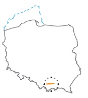
Acreage: 218,902 km2; 54,092 acres
Concession blocks: 393, 412, 413
Coordinates
| No. point | x [PUWG92] | y [PUWG92] |
| 1 | 234 844,36 | 560 392,57 |
| 2 | 236 207,60 | 566 125,53 |
| 3 | 236 033,68 | 566 047,35 |
| 4 | 235 039,21 | 566 833,73 |
| 5 | 234 435,41 | 567 891,74 |
| 6 | 234 919,04 | 569 098,08 |
| 7 | 236 899,73 | 569 036,20 |
| 8 | 237 511,44 | 571 608,68 |
| 9 | 238 239,18 | 593 185,13 |
| 10 | 235 643,89 | 601 614,75 |
| 11 | 232 987,60 | 601 605,37 |
| 12 | 232 886,20 | 599 665,94 |
| 13 | 234 314,53 | 599 626,24 |
| 14 | 234 138,40 | 593 300,61 |
| 15 | 232 471,03 | 593 346,94 |
| 16 | 231 635,97 | 587 283,16 |
| 17 | 231 660,82 | 587 179,60 |
| 18 | 231 619,15 | 587 161,05 |
| 19 | 231 446,80 | 585 909,50 |
| 20 | 231 067,40 | 576 041,64 |
| 21 | 231 535,86 | 574 373,85 |
| 22 | 231 062,27 | 574 226,57 |
| 23 | 230 992,76 | 574 100,13 |
| 24 | 230 896,96 | 571 608,57 |
| 25 | 230 642,81 | 560 453,66 |
| 26 | 236 852,99 | 574 680,84 |
| 27 | 236 886,19 | 575 398,94 |
| 28 | 235 707,30 | 575 415,67 |
| 29 | 235 696,65 | 574 665,74 |
| 30 | 236 756,07 | 574 650,71 |
Location
Małopolskie province:
- Kraków county, communes: Skawina (participation in the concession block 1.7%), Mogilany (11.50%), Świątniki Górne (4.85%)
- Kraków city county: commune: Kraków (6,13%)
- Wieliczka county, communes: Wieliczka (23.53%), Niepołomice (5.57%), Kłaj (13.88%), Biskupice (15.53%), Gdów (9.36%)
- Bochnia county: commune: Bochnia (5.53%), Bochnia (city) (2.41%)
Duration
concession for 10 years, including:
- prospecting and exploration phase (5 years)
- extracting phase - after the investment decision
Petroleum play
I – Palaeozoic–Mesozoic of the Carpathian basement
II – flysch of the Carpathian nappes
III – Carpathian Foredeep
Source rocks
I – Lower Carboniferous clastic and carbonate rocks, Upper Carboniferous clastic rocks, Middle Jurassic mudstones and claystones
II – Lower Cretaceous Cieszyn Beds, Wierzowice Beds, Grodziszcze Beds, Lgota Beds, Oligocene Menilite shales of all nappe units
III – Carpathian Foredeep fine-grained rocks
Reservoir rocks
I – Cambrian sandstones, Lower Devonian limestones and dolomites, Upper Devonian limestones and dolomites, Upper Jurassic limestones, Cenomanian Sandstones
II – flysch of the Silesian Unit: Grodziszcze Beds, Wierzowice Beds, Lgota Beds, sandstones of Ciężkowice, Menilite and Krosno bedsflysch of the Sub-Silesian Unit: Wierzowice and Lgota beds
III – clastic rocks of the autochthonous Miocene (sand and sandstones of the Upper Badenian and Lower Sarmatian)
Seal rocks
I – evaporites and fine-grained deposits of the autochthonous Miocene of the Carpathian Foredeep
II – fine-grained flysch deposits
III – fine-grained flysch deposits and fine-grained deposits of the autochthonous Miocene of the Carpathian Foredeep
Trap type
I – structural, stratigraphic
II – structural, structural-lithological, lithological
III – structural, compactional anticlines
The proposed minimum work program of prospecting and exploration phase
Stage I (12 months) – reprocessing and reinterpretation of archival seismic 2D data
Stage II (12 months) – acquisition 50 km2 of new 3D seismic survey or 50 km of 2D survey
Stage III (24 months) – drilling of one exploration well to the minimal depth of 1,100 m (TVD) and maximal depth of 4,500 m with obligatory coring of perspective intervals and full set of geophysical data allowing to interpret lithology, saturation and petrophysical properties as well as to ensure safety during the drilling process. In the case of discovery – performance of production tests and determination of exploitation parameters
Stage IV (12 months) – analysis of obtained data
