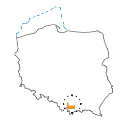
Acreage: 981,67 km2; 242,575 acres
Concession blocks: 412, 413, 432 i 433
Coordinates
| No. point | x [PUWG92] | y [PUWG92] |
| 1 | 237 088,56 | 543 233,92 |
| 2 | 230 254,64 | 543 416,61 |
| 3 | 218 462,26 | 543 731,87 |
| 4 | 218 661,71 | 552 238,18 |
| 5 | 219 634,17 | 553 786,28 |
| 6 | 218 677,07 | 553 795,86 |
| 7 | 218 918,27 | 574 085,44 |
| 8 | 221 028,90 | 577 051,28 |
| 9 | 221 144,84 | 580 743,36 |
| 10 | 219 005,58 | 580 176,25 |
| 11 | 199 583,78 | 580 168,79 |
| 12 | 200 075,62 | 536 193,52 |
| 13 | 237 064,53 | 535 946,93 |
Location
Województwo małopolskie:
- Kraków county, commune: Czernichów (participation in the concession block 0.16%)
- Limanowa county, communes: Mszana Dolna (3.89%), urban Mszana Dolna (2.41%)
- Myślenice county, communes: Pcim (9.05%), Lubień (6.05%), Dobczyce (1.04%), Myślenice (6.30%), Raciechowice (0.39%), Tokarnia (6.98%), Sułkowice (2.37%), Wiśniowa (4.91%)
- Nowy Targ county, commune Rabka-Zdrój (<1%)
- Sucha Beskidzka county, communes Sucha Beskidzka (2.81%), Jordanów (0.58%), Bystra-Sidzina (0.10%), Budzów (7.48%), Jordanów (5.17%), Zawoja (2.47%), Maków Podhalański (10.32%), Stryszawa (3.92%), Zembrzyce (3.52%)
- Wadowice county, communes: Wadowice (5.12%), Kalwaria Zebrzydowska (0.69%), Brzeźnica (2.60%), Stryszów (3.35%), Mucharz (2.76%), Lanckorona (1.06%), Spytkowice (2.42%), Tomice (2.09%)
Duration
Concession for 10 years, including:
- prospecting and exploration phase (5 years)
- extracting phase - after the investment decision
Petroleum play
I – Palaeozoic and Mesozoic basement of the Carpathians
II – Carpathian nappes
III – Autochthonous Miocene in the Carpathian Foredeep
Source rocks
I – Lower Carboniferous clastic rocks, Upper Carboniferous clastic rocks (paralic and limnic series), Middle Jurassic mudstones and claystones
II – Lower Cretaceous Cieszyn Beds, Wierzowice Beds, Grodziszce Beds, Lgota Beds; Oligocene Beds – menilite shales
III – Fine grained clastic rocks of the autochthonous Miocene of the Carpathian Foredeep
Reservoir rocks
I – Cambrian sandstones; Devonian and Lower Carboniferous limestones and dolomites; clastic rocks of the Upper Carboniferous (Productive series); Upper Jurassic limestones
II – flysch of Magura Nappe, Dukla/Grybów Nappe, Subsilesian Nappe, Silesian Nappe
III – sandstones and mudstones of the autochthonous Miocene of the Carpathian Foredeep
Seal rocks
I – Carboniferous fine-grained clastic rocks and finegrained clastic rocks of the autochthonous Miocene of the Carpathian Foredeep
II, III – Fine-grained flysch deposits and fine-grained clastic rocks of the autochthonous Miocene of the Carpathian Foredeep
Trap type
I – structural, stratigraphic
II – structural, structural-lithological, lithological
III – compaction anticlines, structural, stratigraphic
The proposed minimum work program of prospecting and exploration phase
Stage I (12 months) – reprocessing and reinterpretation of archival seismic 2D data
Stage II (12 months) – acquisition 50 km of 2D survey
Stage III (24 months) – drilling of one exploration well to 4,500 m (TVD) with obligatory coring of perspective intervals and full set of geophysical data allowing to interpret lithology, saturation and petrophysical properties as well as to ensure safety during the drilling process. In the case of discovery – performance of production tests and determination of exploitation parameters
Stage IV (12 months) – analysis of obtained data
