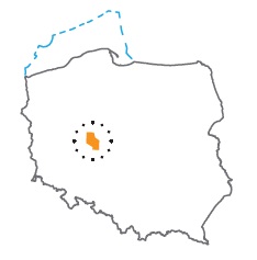
Acreage: 1138,34 km2; 281,289 acres
Concession blocks: 186, 166, 206
Coordinates
| No. point | x [PUWG92] | y [PUWG92] |
| 1 | 554 275,83 | 350 362,87 |
| 2 | 540 476,39 | 353 736,92 |
| 3 | 532 656,26 | 364 597,08 |
| 4 | 516 752,54 | 364 155,53 |
| 5 | 507 487,33 | 363 899,15 |
| 6 | 508 036,81 | 346 455,31 |
| 7 | 514 844,00 | 348 080,26 |
| 8 | 525 964,31 | 330 432,62 |
| 9 | 554 868,38 | 331 517,04 |
Location
Wielkopolskie province:
- Czarnków-Trzcianka county, communes: Czarnków (participation in the concession block <1%)
- Oborniki county, communes: Rogoźno (<1%), Oborniki (29.56%), Ryczywół (3.22%)
- Poznań City county, commune Poznań City (8.91%)
- Poznań county, communes: Dopiewo (<1%), Murowana Goślina (3.85%), Czerwonak (2.54%), Tarnowo Podgórne (1.37%), Rokietnica (5.35%), Suchy Las (10.18%)
- Szamotuły county, communes: Obrzycko (6.64%), Obrzycko City (<1%), Szamotuły (11.54%), Ostroróg (<1%), Kaźmierz (<1%)
Duration
Concession for 10 years, including:
- prospecting and exploration phase (5 years)
- extracting phase - after the investment decision
Petroleum play
I – Conventional in the Upper Palaeozoic (Carboniferous) and Permian (Rotliegend, Zechstein/Zechstein Limestone and Main Dolomite)
II – Unconventional (tight gas) in the Rotliegend and Carboniferous sandstones
Source rocks
I – Lower Carboniferous claystones and mudstones; Permian (Zechstein/Main Dolomite) organic-rich interbeds
II – Lower Carboniferous claystones and mudstones
Reservoir rocks
I – Rotliegend sandstones and Zechstein limestones and dolomites
II – Rotliegend and Carboniferous sandstones
Seal rocks
I, II – salt or clay levels within the Rotliegend sandstones; playa sediments in the upper part of Rotliegend sandstones; Zechstein eveporites
Trap type
I – structural, tectonic, lithological, facies
II – unconventional tight gas: Basin Centered Gas System
The proposed minimum work program of prospecting and exploration phase
Stage I (12 months) – reprocessing, integration and reinterpretation of archival seismic and well logs data
Stage II (24 months) – drilling of two exploration well to the maximal depth of 6,000 m (TVD) with obligatory coring of prospective intervals and full set of geophysical data allowing to interpret lithology, saturation and petrophysical properties as well as to ensure safety during the drilling process
Stage III (12 months) – exploration tests in previously found zones and estimation of the production parameters (in case of discover)
Stage IV (12 months) – analysis of obtained data
