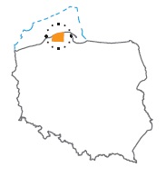
Acreage: 1039,29 km2; 256,814 acres
Concession blocks: 7,8, 27, 28, 47, 48
Coordinates
| No. point | x [PUWG92] | y [PUWG92] |
| 1 | 768 487,61 | 409 502,87 |
| 2 | 736 256,30 | 408 926,76 |
| 3 | 737 349,02 | 370 473,15 |
| 4 | 754 461,09 | 370 959,42 |
Location
Pomorskie province:
- Słupsk county, communes: Ustka (participation in the concession block 7.40%), Smołdzino (25.01%), Słupsk (9.48%), Główczyce (30.57%), Damnica (10.15%), Potęgowo (7.17%)
- Słupsk city county: commune Słupsk (0.50%)
- Lębork county: communes Nowa Wieś Lęborska (2.19%), Wicko (6.51%), Łeba (1.02%)
Duration
Concession for 10 years, including:
- prospecting and exploration phase (5 years),
- extracting phase - after the investment decision.
Petroleum play
I – Unconventional in the Lower Palaeozoic (Middle and Upper Cambrian, Ordovician, Silurian)
II – Conventional in the Middle Cambrian
Reservoir rocks
I – Upper Cambrian, Odrovician and Silurian claystones and mudstones
II – Middle Cambrian sandstones
Seal rocks
I, II – Upper Cambrian and Silurian (Ludlovian and Pridoli) claystones and mudstones; Zechstein evaporites
The proposed minimum work program of prospecting and exploration phase
Stage I (12 months) – reprocessing and reinterpretation of archival seismic 2D data and geological data
Stage II (12 months) – acquisition 100 km2 of new 3D seismic survey or 80 km of 2D survey
Stage III (24 months) – drilling of one exploration well to 3,500 m (TVD) with obligatory coring of perspective intervals and full set of geophysical data allowing to interpret lithology, saturation and petrophysical properties as well as to ensure safety during the drilling process. In the case of discovery – performance of production tests and determination of exploitation parameters
Stage IV (12 months) – analysis of obtained data
