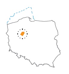
Acreage: 1070,01 km2; 264,405 acres
Concession blocks: 126, 127, 146, 147
Coordinates
| No. point | x [PUWG92] | y [PUWG92] |
| 1 | 595 210,98 | 355 930,04 |
| 2 | 620 491,44 | 375 248,55 |
| 3 | 619 965,85 | 400 258,03 |
| 4 | 604 743,94 | 399 937,40 |
| 5 | 581 913,05 | 381 692,43 |
Location
Wielkopolskie province:
- Piła county, communes: Kaczory (participation in the concession block 1.82%), Białośliwie (3.75%), Łobżenica (17.80%), Miasteczko Krajeńskie (0.12%), Wysoka (11.13%), Wyrzysk (9.78%)
- Złotów county, communes: Złotów (12.02%), urban Złotów (0.71%), Krajenka (11.04%), Lipka (0.52%), Zakrzewo (10.71%)
Kujawsko–pomorskie province:
- Nakło county, communes: Mrocza (0.53%), Sadki (1.23%)
- Sępólno Krajeńskie county, communes: Sępólno Krajeńskie (3.31%), Więcbork (15.53%)
Duration
Concession for 10 years, including:
- prospecting and exploration phase (5 years)
- extracting phase - after the investment decision
Source rocks
I – Lower Carboniferous claystones and mudstones
II – Permian (Zechstein/Main Dolomite) organic-rich interbeds
Seal rocks
I – claystone interbeds within Rotliegend reservoirs, Zechstein evaporites
II – Zechstein evaporites
Trap type
I – Carboniferous – stratigraphic and tectonic
I – Rotliegend – structural, tectonic, lithological
II – Zechstein/Main Dolomite – lithologic-facies, structural
The proposed minimum work program of prospecting and exploration phase
Stage I (12 months) – reprocessing and reinterpretation of archival 2D seismic data
Stage II (12 months) – execution of 3D seismic survey (100 km2 ) or 2D seismic survey (80 km)
Stage III (24 months) – drilling of one well to the depth of 5,000 m (TVD) with obligatory coring of perspective intervals and full set of geophysical data allowing to interpret lithology, saturation and petrophysical properties as well as to ensure safety during the drilling process
Stage IV (12 months) – analysis of the obtained data
