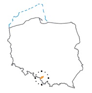
Acreage: 78,13 km2; 19,306 acres
Concession blocks: 410
Coordinates
| No. point | x [PUWG92] | y [PUWG92] |
| 1 | 223 340,94 | 469 349,26 |
| 2 | 222 006,67 | 472 341,47 |
| 3 | 222 610,87 | 475 471,89 |
| 4 | 223 408,87 | 477 661,45 |
| 5 | 223 490,93 | 477 887,19 |
| 6 | 223 872,41 | 477 770,44 |
| 7 | 224 715,17 | 478 337,62 |
| 8 | 226 020,64 | 480 953,53 |
| 9 | 226 659,26 | 481 410,03 |
| 10 | 228 475,40 | 483 189,30 |
| 11 | 232 280,91 | 483 100,65 |
| 12 | 232 607,78 | 481 113,12 |
| 13 | 231 745,42 | 481 101,58 |
| 14 | 231 189,04 | 481 094,03 |
| 15 | 231 180,98 | 479 634,88 |
| 16 | 231 169,88 | 477 598,39 |
| 17 | 231 156,89 | 475 397,84 |
| 18 | 230 950,90 | 474 068,29 |
| 19 | 228 321,62 | 475 516,68 |
| 20 | 228 295,53 | 473 508,54 |
| 21 | 226 222,77 | 472 027,00 |
| 22 | 226 539,15 | 470 772,91 |
| 23 | 225 113,26 | 469 919,35 |
| 24 | 224 334,23 | 469 624,94 |
Location
Śląskie province:
- Cieszyn county, communes: Strumień (participation in the concession block 15,86%), Zebrzydowice (22,41%),
- Pszczyna county, communes: Pławowice (45,37%), Pszczyna (5,09%),
- Jastrzębie Zdrój county, commune Jastrzębie Zdrój (11,27%).
Duration
Concession for 10 years, including:
- prospecting and exploration phase (5 years),
- extracting phase - after the investment decision.
The proposed minimum work program of prospecting and exploration phase
Stage I (12 months – reinterpretation of archival geological data
Stage II (12 months) – drilling of two wells to the minimum depth of 1600 m with obligatory coring of perspective intervals
Stage III (24 months) – drilling of three wells to the minimum depth of 1600 m with obligatory coring of perspective intervals and full set of geophysical data allowing to interpret lithology, saturation and petrophysical properties as well as to ensure safety during the drilling process. In the case of discovery – performance of production tests and determination of exploitation parameters
Stage IV (12 months) – analysis of obtained data
