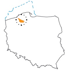
Acreage: 1198,68 km2; 296,200 acres
Concession blocks: 44, 45, 64, 65, 66, 85, 86
Coordinates
| No. point | x [PUWG92] | y [PUWG92] |
| 1 | 715 670,70 | 310 109,45 |
| 2 | 700 643,56 | 334 294,55 |
| 3 | 693 802,91 | 355 613,42 |
| 4 | 683 626,15 | 367 870,25 |
| 5 | 683 970,00 | 355 934,00 |
| 6 | 679 751,10 | 355 587,90 |
| 7 | 674 341,90 | 364 585,50 |
| 8 | 675 685,50 | 326 742,49 |
| 9 | 687 105,19 | 314 298,74 |
| 10 | 703 434,00 | 314 956,00 |
| 11 | 703 794,00 | 310 744,00 |
| 12 | 708 568,00 | 304 275,00 |
| 13 | 714 115,84 | 304 001,24 |
Location
Pomorskie province:
- Słupsk county, commune Kępice (participation in the concession block <0.01%)
- Bytów county, commune: Miastko (4.92%)
Zachodniopomorskie province:
- Białogard county, communes: Białogard (0.16%), Tychowo (9.10%)
- Koszalin city county, commune urban Koszalin (6.65%)
- Koszalin county: communes Bobolice (27.64%), Biesiekierz (1.33%), Będzino (3.64%), Świeszyno (6.77%), Mielno (1.47%), Manowo (15.70%), Sianów (1.57%), Polanów (16.15%)
- Szczecinek county, communes: Grzmiąca(< 0.01%), Biały Bór (4.89%)
Duration
Concession for 10 years, including:
- prospecting and exploration phase (5 years)
- extracting phase - after the investment decision
Petroleum play
I – Lower Palaeozoic (Ordovician), Upper Palaeozoic (Devonian, Carboniferous) and Permian (Rotliegend)
II – Permian (Zechstein/Main Dolomite)
Reservoir rocks
I – Devonian sandstones and carbonate rocks, Carboniferous sandstones and secondary carbonate rocks, Permian (Rotliegend) sandstones
II – Permian (Zechstein/Main Dolomite) dolomites
Seal rocks
I, II – Lower Palaeozoic claystones and mudstones in the fault zones; Devonian and Carboniferous claystones and mudstones interbeds; Zechstein evaporites
Trap type
I – Devonian and Carboniferous – stratigraphic and tectonic
I – Rotliegend – structural, tectonic and stratigraphic
II – Main Dolomite – lithological-facies and structural
The proposed minimum work program of prospecting and exploration phase
Stage I (12 months) – reprocessing and reinterpretation of archival seismic 2D data
Stage II (12 months) – acquisition 100 km2 of new 3D seismic survey or 80 km of 2D survey
Stage III (24 months) – drilling of one exploration well to depth of 3,500 m (TVD) with obligatory coring of perspective intervals and full set of geophysical data allowing to interpret lithology, saturation and petrophysical properties as well as to ensure safety during the drilling process. In the case of discovery – performance of production tests and determination of exploitation parameters
Stage IV (12 months) – analysis of obtained data
