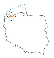
Acreage: 1163,45 km2; 287,494 acres
Concession blocks: 23, 43, 44, 45, 63, 64
Coordinates
| No. point | x [PUWG92] | y [PUWG92] |
| 1 | 748 990,83 | 254 127,55 |
| 2 | 715 785,65 | 310 523,64 |
| 3 | 703 708,09 | 256 083,68 |
| 4 | 718 306,78 | 251 520,76 |
| 5 | 724 448,95 | 266 151,69 |
| 6 | 744 988,72 | 252 740,85 |
Duration
Concession for 10 years, including:
- prospecting and exploration phase (5 years)
- extracting phase - after the investment decision
Petroleum play
I - Lower Palaeozoic (Ordovician), Upper Palaeozoic (Devonian, Carboniferous) and Permian (Rotliegend)
II - Zechstein (Main Dolomite)
Source rocks
- Ordovician mudstones and claystones
- Upper Devonian Marls
- Lower Carboniferous mudstones and claystones
- Main Dolomite
Reservoir rocks
I - Devonian and Carboniferous sandstones and carbonates
II - Zechstein dolomites and limestones
Seal rocks
I, II - Zechstein evaporites; mudstone and siltstone interbeds withic Devonian and Carboniferous reservoir rocks, Lower Palaeozoic mudstones and siltstones in the thrust zones
Trap type
I - Devonian and Carboniferous - stratigraphic and tectonic, Rotliegend - structural, tectonic, lithological
II - Main Dolomite - lithological-facies
The proposed minimum work program of prospecting and exploration phase
Stage I (12 months) – reprocessing, integration and reinterpretation of archival seismic and well logs data
Stage II (24 months) – drilling of one exploration well to the maximal depth of 3500 m (TVD) with obligatory coring of prospective intervals and full set of geophysical data allowing to interpret lithology, saturation and petrophysical properties as well as to ensure safety during the drilling process
Stage III (12 months) – analysis of obtained data
