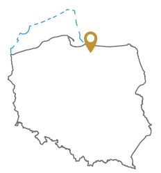
Acreage: 787,86 km2; 194,684 acres
Concession blocks: 52, 72 and 73
Coordinates
| No. point | x [PUWG92] | y [PUWG92] |
| 1 | 729538,36 | 564733,40 |
| 2 | 709963,78 | 565011,05 |
| 3 | 710223,32 | 581294,37 |
| 4 | 700954,70 | 581458,40 |
| 5 | 682448,80 | 581910,30 |
| 6 | 682188,89 | 565550,66 |
| 7 | 701857,78 | 565272,71 |
| 8 | 701752,91 | 555392,38 |
| 9 | 707980,87 | 552672,76 |
| 10 | 723281,12 | 553038,73 |
| 11 | 731168,11 | 553059,46 |
Location
Warmińsko-Mazurskie province:
- Braniewo county, communes: Braniewo (19.65% participation in the concession block), Płoskinia (16.85%), Pieniężno (13.43%), Wilczęta (6.07%), urban Braniewo (0.93% )
- Elbląg county, commune: Godkowo (3.02%)
- Lidzbark county, communes: Orneta (24.29%), Lubomino (8.13%)
- Olsztyn county, commune: Świątki (<0.01%)
- Ostróda county, commune: Miłakowo (7.62%)
Duration
Concession for 10 years, including:
- prospecting and exploration phase (4.5 years)
- extracting phase - after the investment decision
Petroleum play
I – Cambrian conventional and unconventional (tight oil)
II – Lower Palaeozoic unconventional (tight oil, shale oil)
Reservoir rocks
I – Middle Cambrian sandstones
II – Ordovician and Silurian limestones, marls, siltstones and claystones
The proposed minimum work program of prospecting and exploration phase
Stage I (18 months) – reprocessing, integration and reinterpretation of archival seismic and boreholes data
Stage II (24 months) – drilling of one well to the depth of 3500 m (TVD) with obligatory coring of perspective intervals and geophysical survey for petrographic and lithological analyses, hydrocarbon saturation and ensuring security during geological working. In case of deposit discover – performing of production tests and prepare to exploitation
Stage III (12 months) – performance analysis of the data obtained
