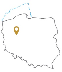
Acreage: 1,119.08 km2; 276,530 acres
Concession blocks: 166 and 167
Coordinates
| No. point | x [PUWG92] | y [PUWG92] |
| 1 | 553208,82 | 391696,38 |
| 2 | 543811,58 | 398404,58 |
| 3 | 544249,21 | 376171,46 |
| 4 | 544548,71 | 364927,26 |
| 5 | 553809,82 | 365184,38 |
| 6 | 554864,44 | 331642,37 |
| 7 | 573431,06 | 332289,06 |
| 8 | 572875,62 | 349057,65 |
| 9 | 572026,54 | 378791,78 |
| 10 | 563112,93 | 365568,76 |
| 11 | 562674,12 | 382371,14 |
| 12 | 553408,12 | 382145,42 |
Location
Wielkopolskie province:
- Żnin county, commune: Janowiec Wielkopolski (1.41% participation in the concession block)
- Chodzież county, communes: Budzyń (17.79%), Chodzież (10.51%), Margonin (5.36%), urban Chodzież (0.93%), Szamocin (0.03%)
- Czarnków-Trzcianka county, communes: Czarnków (19.96%), Lubasz (3.63%), urban Czarnków (0.91%), Połajewo (0.69%), Trzcianka (0.62%)
- Oborniki county, communes: Ryczywół (3.24%), Rogoźno (2.52%)
- Piła county, commune: Ujście (2.43%)
- Wągrowiec county, communes: Wągrowiec (24.40%), Mieścisko (2.76%), urban Wągrowiec (1.59%), Damasławek (1.10%), Gołańcz (0.12%)
Duration
Concession for 10 years, including:
- prospecting and exploration phase (5 years)
- extracting phase - after the investment decision
Petroleum play
I – Conventional in Permian (Rotliegend)
II – Unconventional (tight gas) in Permian (Rotliegend)
The proposed minimum work program of prospecting and exploration phase
Stage I (12 months) – interpretation and analyses of the archival geological data
Stage II (12 months) – execution of 2D seismic survey (at least 100 km)
Stage III (24 months) – drilling of one well to the depth of 5500 m (TVD) with obligatory coring of perspective intervals and geophysical survey for petrographic and lithological analyses, hydrocarbon saturation and ensuring security during geological work. In case of deposit discover – performing of production tests and preparing to exploitation
Stage IV (12 months) – analysis of the data obtained
