Acreage: 709.63 km2; 175,353 acres
Concession blocks: 5, 6, 14 and 15
Coordinates
| No. point | x [PUWG92] | y [PUWG92] |
| 1 | 765579.52 | 435528.73 |
| 2 | 759982.46 | 460170.68 |
| 3 | 737259.22 | 467502.29 |
| 4 | 737770.93 | 435133.01 |
Location
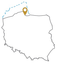
Pomorskie province:
- Gdynia urban county, commune: urban Gdynia (participation in the concession blocks: 5.57%)
- Puck county, communes: Puck (14.77), Krokowa (2.92%), Kosakowo (1.45%)
- Wejherowo county, communes: Wejherowo (27.18%), Luzino (14.57%), Gniewino (11.84%), Łęczyce (5.15%), Reda (4.71%), Rumia (4.23%), Szemud (3.82%), urban Wejherowo (3.80%), Linia (<0.01%)
Duration
Concession for 10 years, including:
- prospecting and exploration phase (4.5 years)
- extracting phase - after the investment decision
Petroleum play
I – conventional and unconventional for tight oil and tight gas in the Cambrian
II –unconventional for oil and gas from shale formations in the Lower Paleozoic
Source rocks
I, II – Upper Cambrian (Piaśnica Fm.), Ordovician (Sasino Fm.) and Silurian (Jantar Mbr.) fine-grained clastics
Reservoir rocks
I – Middle Cambrian sandstones
II – Upper Cambrian (Piaśnica Fm.), Ordovician (Sasino Fm.) and Silurian (Pelplin Fm.) claystones and mudstones (Jantar Mbr.)
The proposed minimum work program of prospecting and exploration phase
Stage I (18 months) – interpretation and analyses of the archival geological data
Stage II (24 months) – drilling of one well to the depth of 5000 m (TVD) and geophysical survey for petrographic and lithological analyses, hydrocarbon saturation and ensuring security during geological work. In case of deposit discover – performing of production tests and preparing to exploitation
Stage III (12 months) – analysis of the obtained data
