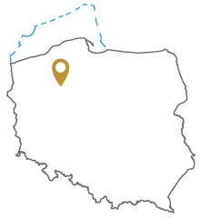
Acreage: 943.37 km2; 233,112 acres
Concession blocks: 146 and 147
Coordinates
| No. point | x [PUWG92] | y [PUWG92] |
| 1 | 583341,11 | 378925,81 |
| 2 | 572026,54 | 378791,78 |
| 3 | 572875,62 | 349057,65 |
| 4 | 580980,15 | 332427,20 |
| 5 | 601193,83 | 333133,14 |
| 6 | 600818,16 | 345067,12 |
Location
Wielkopolskie province:
- Chodzież county, communes: Chodzież (10.08% powierzchni), Szamocin (8.68%), Margonin (1.37%), urban Chodzież (0.25%)
- Czarnków-Trzcianka county, communes: Trzcianka (9.51%), Czarnków (0.16%)
- Piła county, communes: Szydłowo (18.53%), Kaczory (13.89%), urban Piła (10.88%), Ujście (9.39%), Miasteczko Krajeńskie (7.37%), Białośliwie (3.50%), Wysoka (0.40%)
- Wągrowiec county, commune: Gołańcz (0.09%)
- Złotów county, commune: Krajenka (2.00%)
Zachodniopomorskie province:
- Wałcz county, commune: Wałcz (3.92%)
Duration
Concession for 10 years, including:
- prospecting and exploration phase (5 years)
- extracting phase - after the investment decision
Petroleum play
I – conventional in Permian/Rotliegend
II – unconventional tight gas in Permian/Rotliegend
The proposed minimum work program of prospecting and exploration phase
Stage I (12 months) – interpretation and analyses of the archival geological data
Stage II (12 months) – execution of 2D seismic survey (100 km)
Stage III (24 months) – drilling of one well to the maximum depth of 6000 m (TVD) with obligatory coring of perspective intervals and geophysical survey for petrographic and lithological analyses, hydrocarbon saturation and ensuring security during geological work. In case of deposit discover – performing of production tests and preparing to exploitation
Stage IV (12 months) – analysis of the obtained data
