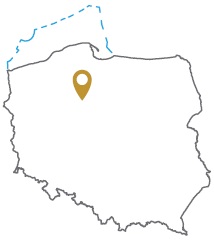
Acreage: 423.43 km2; 104,631 acres
Concession blocks: 127, 128, 147 and 148
Coordinates
| No. point | x [PUWG92] | y [PUWG92] |
| 1 | 594148,37 | 426960,10 |
| 2 | 582363,26 | 418634,95 |
| 3 | 599426,14 | 395809,11 |
| 4 | 604582,91 | 399934,60 |
| 5 | 613883,12 | 400129,96 |
Location
Kujawsko-Pomorskie province:
- Bydgoszcz county, communes: Sicienko (32.28% powierzchni), Białe Błota (1.55%), Koronowo (0.24%)
- Nakło county, communes: Mrocza (30.24%), Nakło nad Notecią (15.67%), Szubin (0.11%), Sadki (<0.1%)
- Sępólno county, communes: Więcbork (12.30%), Sośno (7.62%)
Duration
Concession for 10 years, including:
- prospecting and exploration phase (4 years)
- extracting phase - after the investment decision
Source rocks
I – Lower Carboniferous siltstones and claystones
II – (hypotetic) Main Dolomite sediments
Reservoir rocks
I – Carboniferous and Permian/Rotliegend sandstones
II – Permian (Zechstein/Main Dolomite) carbonates
The proposed minimum work program of prospecting and exploration phase
Stage I (12 months) – interpretation and analyses of the archival geological data
Stage II (24 months) – drilling of one well to the minimum depth of 5000 m (TVD) with obligatory coring of perspective intervals and geophysical survey for petrographic and lithological analyses, hydrocarbon saturation and ensuring security during geological work. In case of deposit discover – performing of production tests and preparing to exploitation
Stage III (12 months) – analysis of the obtained data
