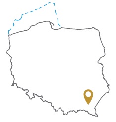
Acreage: 1,103.50 km2; 272,680 acres
Concession blocks: 373 and 393
Coordinates
| No. point | x [PUWG92] | y [PUWG92] |
| 1 | 272376,78 | 574905,78 |
| 2 | 284288,24 | 596762,37 |
| 3 | 284356,69 | 606350,72 |
| 4 | 265797,37 | 606784,68 |
| 5 | 256877,58 | 606993,25 |
| 6 | 256866,90 | 601531,16 |
| 7 | 265972,20 | 601470,88 |
| 8 | 265785,26 | 594508,99 |
| 9 | 256792,10 | 594610,49 |
| 10 | 256861,67 | 598860,04 |
| 11 | 251837,13 | 598803,24 |
| 12 | 245959,17 | 604332,29 |
| 13 | 240684,94 | 604381,02 |
| 14 | 240244,08 | 603139,26 |
| 15 | 238495,59 | 597181,46 |
| 16 | 238239,18 | 593185,13 |
| 17 | 237832,04 | 581113,94 |
| 18 | 245049,27 | 580870,51 |
| 19 | 254016,45 | 575181,98 |
Location
Małopolskie province:
- Bochnia county, communes: Drwina (5.23% powierzchni), Bochnia (0.95%)
- Kraków county, communes: Słomniki (7.68%), Kocmyrzów-Luborzyca (6.64%), Igołomia-Wawrzeńczyce (5.68%), Michałowice (0.11%)
- Kraków urban county, commune: urban Kraków (4.34%)
- Miechów county, communes: Racławice (5.07%), Słaboszów (2.73%), Miechów (2.44%)
- Proszowice county, communes: Koniusza (8.01%), Proszowice (5.32%), Radziemice (5.25%), Pałecznica (4.12%), Nowe Brzesko (2.18%), Koszyce (0.13%)
- Wieliczka county, communes: Niepołomice (7.56%), Kłaj (3.01%), Wieliczka (0.32%)
Świętokrzyskie province:
- Kazimierza county, communes: Skalbmierz (7.78%), Kazimierza Wielka (6.01%), Czarnocin (1.95%)
- Pińczów county, communes: Działoszyce (6,38%), Pińczów (1,01%), Złota (0,07%), Michałów (0,03%)
Duration
Concession for 10 years, including:
- prospecting and exploration phase (5 years)
- extracting phase - after the investment decision
Reservoir rocks
I – Cenomanian (Upper Cretaceous) glauconitic sandstones and litho-Rauracian (lower part of the Upper Oxfordian, Upper Jurassic) detrital limestones
Seal rocks
I – Upper Cretaceous marls and Miocene clay (Krakowieckie Beds) of the Carpathian Foredeep
The proposed minimum work program of prospecting and exploration phase
Stage I (12 months) – interpretation and analyses of the archival geological data
Stage II (12 months) – execution of 2D seismic survey (70 km)
Stage III (24 months) – drilling of one well to the maximum depth of 2500 m (TVD) with obligatory coring of perspective intervals and geophysical survey for petrographic and lithological analyses, hydrocarbon saturation and ensuring security during geological work. In case of deposit discover – performing of production tests and preparing to exploitation
Stage IV (12 months) – analysis of the obtained data
